Typical atmospheric parts and the weather in them - P1
Weather concept
What is the weather?
- The state of the atmosphere on the earth’s surface at a given time, at a particular place, is characterized by a set of values of meteorological factors and their gradual changes over a certain period of time a specific time, called weather.
Weather is variable in time and space. It can change within a certain period, related to the daily and annual course of meteorological elements. - Meanwhile, they also observed non-periodic weather changes that occur independently of the Earth’s daily rotation and circular motion around the Sun. Such changes often co-occur over large areas.
For example, in one region, the daytime temperature drops significantly, while in other areas it rises at night; over these or other areas of the ocean may appear large areas of storms and precipitation… - Acyclic weather changes are associated with the existence and displacement of air masses and atmospheric fronts, the development and passage of cyclones and anticyclones, of which they are a part of forms or are subject to general atmospheric circulation.
What is weather research for?
- A study of the origin and development of weather in one or another part of the atmosphere to derive the laws of evolution of various weather patterns in each structural part of the atmosphere in different physics is significant. It is one of the many primary contents of Sinop meteorology.
- Simonian meteorology, or the science of weather forecasting, is a science that studies the laws of atmospheric processes occurring under different geographical conditions to develop predictive methods for predicting weather changes.
- People use many different methods to predict upcoming weather changes. Sinov’s method is a system of proposals for analyzing atmospheric processes.
The three main features of this method are the investigation of temporal changes in atmospheric processes over a large area and the analysis of the development of these atmospheric processes taking into account the geographical conditions of each region.
A third feature is the combination of qualitative forms of research with quantitative forms that help us calculate the variability of each meteorological element and characteristics of atmospheric circulation, i.e. air flow of different scales. - Atmospheric processes considered in Sinova meteorology occupy ample space and are called macroatmospheric processes. The main processes often discussed are cyclones, anticyclones, air masses or air masses, and atmospheric fronts, for which they have a common name, Si-Nov objects.
These Sinov objects have different, typical physical structures, producing weather that is also typically very different.
Aircrew
Troposphere Definition and Properties
- Most of the air in the troposphere is physically homogeneous, not only in height but also in width.
Homogeneous air masses ranging in thickness from a few hundred meters to more than ten kilometers and thousands of kilometers wide that can exchange between one region of the Earth and another are called air masses. - These giant aerial groups, which may occupy an entire continent or an ocean, differ in common characteristics so that there is no leap in the horizontal, though variable, but slow and continuous plane.
Considering the characteristics of the fleet, a range of values typical of the meteorological elements most distinctive of the fleet is usually given. These characteristics include both slow changes in time and space and changes that are fast enough daily but are generally separate.
Characteristics that are called preserved are specific humidity, absolute humidity, dew point, and horizontal visibility. Properties that are easily variable in time and space are air temperature and relative humidity. - Each corps had numerically defined values of characteristics caused by the conditions of the region where it was formed when the association was formed.
- The properties of the air group depend not only on the properties of the substrate but also on the weather conditions in which it is made.
Formation of an air group
- It is the process of acquiring the characteristic features of the air group.
- Favorable conditions for the formation of an air group are anticyclonic areas, low moving eddies, in alternating barometric fields.
Here, the air can only stand for a long time on uneven ground. This area is called the air group generator furnace. - The temperature regime of the bottom plate in the molding furnace should be almost uniform. Such areas are found only on the ocean’s surface on land with the same cover.
Over an extended period, variable air circulates over areas with the same underside and gradually takes on the characteristics typical of the cavity that forms the airship. - The formation of the troposphere in the lower layers of the troposphere takes several days. The longer the time spent in the air region, the greater the gas properties are now more apparent.
From the point of view of the dependence of the weather condition on the same created drive, the air group can accept several different characteristic values of meteorological factors.
Transformation of the air group
- When the intensity and direction of airflow in the atmosphere changes, the aircrew leaves its own nest and moves to another area. In the process of displacement, it is captured by new influences of the surrounding environment.
It changes the characteristics of the air personnel over time, under the influence of atmospheric circulation and the lower surface called displacement change of flight group. - Airplane crews fly over seas and oceans, they are wetter, and on land – on dry land, if they go in a tropical direction – they get warmer; towards the poles – they get more relaxed.
This should be taken into account when forecasting the weather. The most important thing is to know how and where the airship comes from and how its characteristics can be expected, i.e. what weather conditions.
To do this, air groups must be classified according to different characters. There are two ways of categorizing air groups: by the thermal situation and by geospatial latitude.
Classification according to the thermal state
Air groups are divided into three main types: sustainable and unsustainable cold air groups, sustainable and unsustainable hot air groups, and local and unsustainable air groups.
a. A cold air group is a type of air group that moves from a colder region to a hotter area. The aircrew is cold everywhere you go; the temperature drops. It then slowly heats up by itself.
b. When the group is hot, the air group moves from a warmer region to a more excellent part. Wherever it goes, it’s warmer. And the air group is getting colder by the day.
c. A local air group is a type of air group that stands for a long time in a particular area, maintaining its main characteristics without changing.
Air groups of this type can be relatively cold or hot compared to neighboring air groups according to the conditions of radiative balance.
Groups of cold, hot, and local air can be sustainable according to their energy state. A gas group is said to be stable when the vertical temperature gradient in its lower gas layer is less than the thermal gradient (γ) of the moist adiabatic process (γâ).
Under these conditions, its lower layers of gas become stable, which prevents the development of convective movements – so cumulus clouds cannot form.
The steady state of the air fleet is significantly hot because it moves more to the cold area; the heat will increase there – And it cools down in the lower part, thus creating a slight vertical temperature gradient (γ<γâ).
When the union is said to be unstable if it has a vertical thermal gradient y more incredible than the moisture gradient Ya Under such conditions, its underlying layers are less stable and produce thermal convection (when the moisture reserves are significant), leading to the formation of cumulus clouds and even precipitation.
If the air is arid (condensation is distributed at a reasonably high altitude), cloud formation may not occur.
Usually, the unstable state of a typical air group is cold air if it approaches a hotter region. Along the way, this airship is heated in the lower part, creating a thermal gradient large vertical (γ>γâ).
Classification of air groups by geography
Many groups of geographic classifications take into account the unique characteristics of different regions of the world. However, there are four main types of air groups with other geographical coordinates of formations: polar, near-polar, tropical, and equatorial air groups.
One of the above types of air groups is again divided into maritime and continental air groups, depending on the characteristics of the air groups point and the advantage of the bottom surface of the cavity forming and following the trajectory of the aircrew.
For example, the Arctic Air Corps entered Europe through Scandinavia, and the northwestern part of the Soviet Union called Continental Arctic Air Force; the fleet headed to Europe from the Greenland – Spixbergen – Arctic Sea area because it went through a long stretch over the vast and warm water.
Arctic and Antarctic air forms in the polar circles. The place of their formation is low temperature and low humidity – they have very high stability.
When unions near the poles or midlatitudes, they are formed for long-standing above the mid-latitudes. Its stability depends on the drive it has created and the direction of its movement.
A group of tropical air is the air that forms in the anticyclonic zone of the subtropical location. At the point of its origin, the air heats up, which is why the airship is unstable when there is a lot of moisture.
An equatorial air group is an air that forms at the equator where the temperature is high. Understanding the properties of hot, cold, stable, and unstable air groups and the changes in their physical properties over time allows mariners to judge weather characteristics in which direction to guide ships when traveling across seas and oceans safely in different air groups.
As mentioned above, weather characteristics depend on the type of air group.
As mentioned above, weather characteristics depend on the type of air group.
a. Persistent groups of cold air are observed in winter, over the continents, and in the summer over the frozen regions of the Arctic and Antarctic and not over the seas and oceans.
The weather is typical for them: cloudless, low temperature, occasional radiation blindness, low density near the ground; if there is no blindness – good vision; The daily variation of meteorological factors is large but smaller than in a less stable atmosphere.
b. Persistent bands of hot air are seen more often over oceans and seas during the summer when air moves from warmer continents to relatively calmer waters and during the resulting mixing of oceanic air from friendlier to more fantastic.
On the continents, in winter, we usually encounter air coming in after long-standing over the warmer ocean water. This air group is characterized by: the lower layers of the air being relatively humid, and a temperature inversion is created; no convective clouds; thick stratocumulus or stratocumulus clouds; for drizzle or stratospheric fog formation; high relative humidity, cloud formation cloudy sky due to increase in blindness; reduced air turbulence and wind gusts.
c. When cold bands are unsustainable over the oceans and seas, more typical of winter when cold air from the poles or land moves into relatively warmer waters; in summer, less visible in the downpour coming from the bars.
On the continents, summer is more typical when there is near-polar sea air or the tide of the polar sea. The lower layers of gas are heated with convection, forming cumulus clouds and cumulus clouds, which develop most strongly in the afternoon and at night.
We observe thick silvery clouds, fragments scattered from the ends of storm cloud anvils, and stratocumulus clouds formed during the discharge of cumulus clouds. There are showers of precipitation and occasional thunderstorms.
The turbulence increased, and the wind picked up. Strong winds are seen in the evening and at night. Good view. The diurnal variation of meteorological factors is more significant than in a steady-state atmosphere.
Unsustainable groups of hot air, often seen in winter, over oceans and seas as hot air moves over warmer seas; Summer is more typical for the mainland. In the ocean, commonly found in the tropics.
The warming of the lower gas layer and the formation of cumulus and cumulus clouds characterize this group. In rain showers and thunderstorms with gusty winds, visibility is reduced; Areas of radiation fog may appear.
Front atmosphere
General concept
- The above shows that in the troposphere, air masses of different temperatures exist, standing side by side, and moving relative to each other. Between them, a relatively thin layer of gas is lying at a slight angle to the ground (α<1°).
Suppose each air group is homogeneous according to its properties and the characteristic values of its meteorological elements and varies horizontally. In that case, they can differ very markedly in the transition layer. - The transitional layer between two air groups is called the frontal (or frontal) surface. The frontal can rise to several kilometers, sometimes to the upper limit of the troposphere, where the horizontal spread reaches hundreds and even thousands of kilometers.
The width of the frontal above the ground – is only tens of kilometers. Compared to the size of the air groups, the frontal layer has a nominal horizontal size.
So the frontal intersection with the ground or with some plane is called the front (or front line). Related to the front is the change of all meteorological factors: forming large cloud systems, for precipitation, increasing wind… - The front between two air groups does not last forever and is not an immutable “wall” separating the air masses. Air groups are constantly changing their properties, changing the direction of the air currents. So the front layer is always present and always disappears.
- Fronts between air groups, classified geographically, are called primary (basic) fronts. Strong ground temperature contrasts, large areas of clouds and precipitation, strong winds, and storms are associated with significant fronts.
The front is the boundary between two air groups of the same geographical class, called the secondary front. They are usually weaker in temperature contrast but can be associated with solid precipitation and high winds, accompanied by a marked change in wind direction. - In addition to the tropospheres mentioned above, a series of regions with striking changes are observed in the troposphere in meteorological factors. For example, the lines are not stable in intratropical convergence.
- Unsustainable road – is a non-frontal region. In which the formation process is observed convection of clouds, accompanied by wind gusts—those regions which do not usually extend and are kept in the near evening.
- Intratropical Convergence – a relatively large area of monsoon currents of two parts of the earth. Here, favorable conditions for the uplift of the air are created, leading to the formation of thick cumulus and cumulus clouds and the fall of solid showers. That region is, by convention, distinct from the other areas of the northern and southern tropical belts.
The main fronts are divided into the following categories according to the types of geographical air groups:
Arctic (or Antarctic) Front – separating Arctic (or Antarctic) air from latitude air
medium;
Polar front – separates mid-latitude air from tropical air;
Tropical Front – separates tropical air from equatorial air.
Depending on the direction of movement, people are divided into hot front, cold front, and slow-moving front.
The front is called hot; when it moves towards colder air, cold air moves back, and warm air moves forward to take its place.
The front is called cold – when hot air is replaced by cold air front moves less often referred to as the very slow-moving type. It is then difficult to establish its characteristic – hot or cold.
In addition to the hot and cold front, there is also the blunt front, which is a complex front (on the junction of the hot show and the cold front).
The frontal face is inclined to the ground. That inclination remains the same for a long time because an equilibrium arises under the action of the Coriolis force.
The Frontal always inclines away from the vertical, towards cold air, and this inclination increases with latitude. At the equator, no frontal is formed.
This inclination angle also increases with the decrease of the hot and cold air temperature difference and with significant step changes in wind speed when switching from one air group to another.
Front hot
- In Figure 1, the vertical section of a hot-air front is shown as hot because the lighter slithers up over the wedge of cold air.
- As it rises, the hot air cools down. At a certain altitude, where the atmosphere reaches saturation, vapor water condenses to form thick clouds, typical for hot fronts. That cloud system includes cirrus clouds (Ci); cloud ti-stratum (Cs); middle cloud-stratum (as); and rattan-stratum (Ns); forming a giant cloud system.
Under the front, clouds As and Ns usually give precipitation, and as a result of evaporation, the air cools down, forming delicate weather clouds (Cufrastus). In the cold air, under the residual gas layers, stratospheric clouds (St) or stratocumulus clouds (Sc). - In a stable atmosphere, stratum clouds (St) are possibly formed in dense air masses, together with stratosphere clouds (Ns) both in front and behind the show. In an unstable hot air group, usually the development of intragastric cumulus clouds.
- The hot front infrequently has a dense cloud mass, sometimes, as a result of evaporation and flat motion, on individual parts of the show “windows,” and cloudless furrows are formed between the cloud’s cloud layer.
- Before the hot front line, a wide range of average precipitation is observed. Its breadth reaches 300 – 400 km. However, when the hot air state is stable and when the amount of moisture is low, this front passes through without giving precipitation.
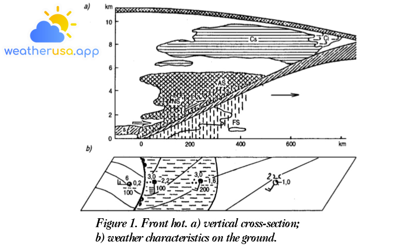
Figure 1. Front hot. a) vertical cross-section; b) weather characteristics on the ground.
In the approach of the hot front, due to the increase in pressure gradient, causing the wind to strengthen, it can reach its maximum speed before the front line. After the front passes, the current decreases again.
Table 1 – some things to know about the change of meteorological factors and phenomena when the hot front passes.
The speed of movement of the hot front on middle latitudes fluctuates in the range of 25 – 60 km/h. Thus, from the time of appearance of Ci and Cs clouds, regular (moderate) precipitation can begin in the active ship zone 10-12 hours later, and after 20-30 hours, the front line will pass.
Table 1. Meteorological factors and phenomena when the hot front comes and goes.
| Meteorological factors and phenomena | In front of the front | When the front is hot | Behind the front
|
| Barometric | Decreasing, usually steadily decreasing | Decreasing slowly | Small decrease or slight increase |
| Wind | Increase. The direction is less counterclockwise in the Northern Hemisphere. | The wind direction is clockwise in B.C.C. | The wind direction remains unchanged, the intensity decreases, and the population decreases. |
| Temperature | No change or slight increase | Increase | Little change |
| Cloud | Appeared in turn Ci, Cs, as Ns | Below Ns accompanied by thin clouds Fmb | St or Sc |
| Precipitation | Precipitation (rain or snow) 300-400km front front. | Almost stopped | Chance of sporadic rain or light precipitation |
| Vision | Worse to 2 li and smaller | Substantial drop below 200m | Bad. The front is getting better and better |
| Other phenomena | Sometimes there are storms and waves on the sea | Often there is blindness, and the sea waves decrease | There may be blindness, and waves decrease |
| Optical Phenomena | Before the appearance of the sun Ns, the moon is bright when Cs can have a halo. |
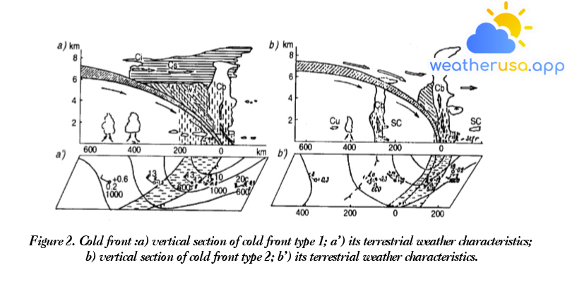
Cold front
- The front is located between hot and cold air, moving towards hot air and cold air gradually encroaching on areas on which hot air previously dominated.
The angle of inclination of the cold front is usually more significant than that of the hot front. There are two types of cold fronts. - Cold front type one (fig.2 a) – is a slow-moving front with them having a cloud system of Ns, as, Cs and Ci. This cloud system reminds us of the cloud system of the hot front, but in the direction of the front’s movement, the distribution is in reverse order.
However, the width of the pattern system and the precipitation is smaller than that of the hot front. Before the front in the hot air can develop cumulonimbus clouds (Cb). - Cold front type 2 (fig.2 b) – is a fast-moving type; associated with them are pre-frontal clouds and pre-frontal precipitation.
Immediately before the cold front of type 2, in a narrow area, strong convection is evident, leading to the development of thick cumulus clouds (Cb), under convective clouds, often with showers of precipitation accompanied by thunderstorms.
Over most of the front, hot air descends. The downward motion of hot air causes the temperature to rise further away from the saturation state. Therefore, there is no cloud growth here.
Some signs of cold front passing are shown in Table 2.
| Meteorological factors and phenomena | In front of the front | When the front crosses | Behind the front
|
| Barometric | Reduction | Stop decreasing and increasing gradually | Increase sharply, then increase slowly or stop increasing |
| Wind | Increases, often counter-clockwise in the Northern Hemisphere | Strong clockwise turn in B.C.C. The strong intensity and gusty winds | The direction turns counter-clockwise in the Northern Hemisphere. Every strong wind as the front passes |
| Temperature | stable or slightly hazy in the pre-frontal precipitation zone | Falling sharply | Continue lowering, or little change |
| Cloud | Clouds are isolated Cc, Ac, as, or replaced by Ns, as, Cs, Ci, or Cb clouds appear. | Ns, Frub, or Cb with Frub | Change the order of Ns, as, Cs, Ci, or the clouds will quickly dissipate after that. |
| Precipitation | The front close to the front is not large, sometimes to some extent quite large. | Normal type, in Cb rattan fence type in batches | Standard type or quick-stop or intermittent barrier type |
| Vision | Getting worse | Bad (500 : 1000) | In the rain: 1 : 2 li |
| Other phenomena | Thunderstorms, often strong with hail | Storms and waves strengthen | Wind waves decrease |
Jagged front
Jagged front formed due to a mixture of hot and cold fronts.
The turbulence of the fronts arises from the difference in their speed of motion. Since the cold front moves faster than the hot front, it will gradually catch up to the hot front. As a result, the molten air slides up, creating a complex cloud system when the fronts meet.
Suppose over some region, and there exist three air groups: two cold and one hot standing in between (fig 3a). These air groups move from the west to the east; the cold front also moves faster than the hot front. At some point, the cold front catches up with the hot front (fig 3b,c,d).
The cloud systems of the two fronts began to combine to form a prison front. If the hot air continues to slide upward, a contact line is raised further away from the ground creating the upper front.
The development of the turbulent process depends on the thermal regime of the cold air groups. If the two cold air groups have the same temperature, the ground front is removed, leaving only an upper front of the fault.
The hot air rests almost entirely on a trough formed by two sides of a given cold and hot front. This front of turbulence is called the intermediate front.
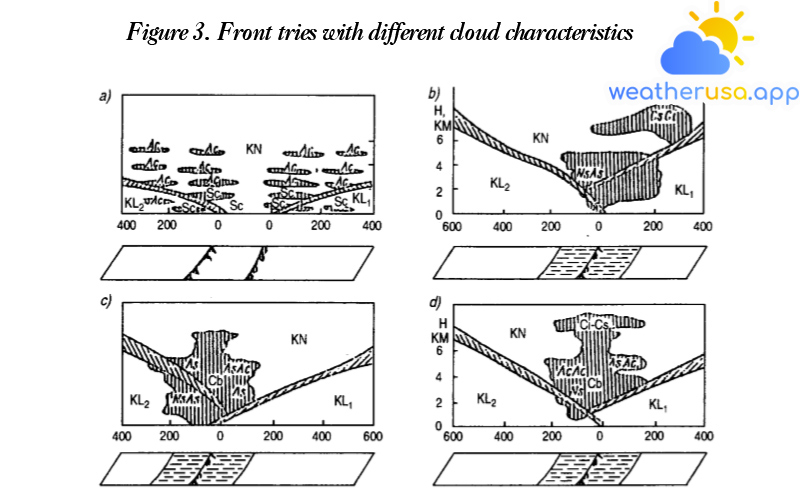
If the hot air in the back is colder than in the front, then the front looks like a cold front. In that case, the face of the hot front appears to slide along the beginning of the cold front (see figure 3 a,b,c).
Here the front is cold below, while the turbulent point is not distributed above the ground, as in the previous case, it is behind the ground front line.
If the cold air behind is hotter than the front, then this front is in the form of a hot front. In this case, the rear air will overflow forward and slide along the hot front (fig 3 c).
The hot front is below, and the turbulent point is not above the ground but deviates forward from the ground front line.
Table 3: Weather phenomena and changes of meteorological factors when the front tries to cross
| Meteorological factors and phenomena | Before the front tries to come
|
When the front of the prison passed by
|
After the front tried to go through
|
|||
| In hot form | In cold form | In hot form | In cold form | In hot form | In cold form | |
| Pressure | Slow down in front of the upper front line, then lower quickly; in front of the front line, tried to lose but weaker in front of the top front. | Lower | Passing through the upper front lower quickly through the front trying to reduce but slower than when the upper front crosses | Fall hard | Behind the upper front is lower; behind the front try to jail – slowly rise. | Go up, then go up |
| Wind | Increase | Increased, often intermittent | Wind direction changes clockwise in the Northern Hemisphere | Occasional gusts of wind | Slowly weaken. Direction changes clockwise in the Northern Hemisphere | Getting weaker, but weak winds can become strong |
| Cloud | Order Ci, Cs, As, Ns, Cb | Order Ci, Cs, As, Sc | St | Cb, As, Ns | As, Cs, Ci, St | Slowly melt, later – Cu or Cb |
| Precipitation | Normal (medium) | Fence | Mostly heavy rain | Fence, medium | The rain fell, then stopped completely | Fence and often stop later |
| Vision | Good, bad | Fight gradually | Bad | Usually a bit bad | In the precipice, it’s a bit bad, and then it gets better faster. | |
There are many features for flat fronts in the distribution of cloud systems, precipitation intensity, duration, and width of the precipitation range.
In the terrestrial barometric field, in many cases, the fronts are associated with prominent barometric gullies because the turbulence occurs in the cyclonic system.
The temperature change during passing and the fronts try to slow down while the crossing of the main front follows the hot front like the weather of the hot main front, and the cold front looks like the weather of the cold front.
Table 3 shows signs of crossing the fronts trying to stay on an observation point. However, it must not be forgotten that the conventions of weather in the frontal region are very diverse and complex because they depend a lot on the type and phase of the turbulence, the characteristics of the barometric field v.v…
Weather caused by a barren front is typical over the mid-latitudes of the Atlantic and Pacific oceans.

Weather 01852 - Lowell MA

54°
clear sky
Feels like 50°05:46/19:39
57°F
/49°F
27%
1031 hPa
7 mi
4 mph


