The bottom of the world ocean
The bottom of the world’s ocean
Bottom terrain
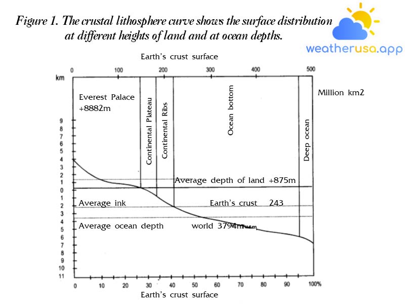
Cross-section of the earth’s crust. Assume that the average cross-section through the earth’s crust in Fig. 1 shows the elevation curve of the lithosphere.
It shows the area correlation between land elevation and ocean depth. This correlation is a very important feature of the earth’s solid crust – the lithosphere.
It shows the area correlation between land elevation and ocean depth. This correlation is a very important feature of the earth’s solid crust – the lithosphere.
- A study of the lithospheric curve found that: only 29% at altitudes above ocean level. On land, the elevation is less than 1000 m, which means mainly lowlands, highlands, and low mountain areas.
They cover 75% of the earth’s surface or 21.4% of the earth’s surface. In the World’s Oceans, there are great depths of 3000 – 6000 m, which represents 75% of their surface or 53.7% of the entire surface of the globe.
On the curve, we see mountains higher than 2000 – 3000 m and the ocean deeper than 6000 m occupying a not very large area.
- The average altitude on the land is 840 m, while the average depth above the world ocean – is 3800 m, which is about 4.5 times greater than the average height of the land.
The vertical distance between the highest peak – Everett and the deepest part of the World Ocean – Mariana is approximately 1:320 of the mean radius of the Earth.
Compared to the size of the globe, the average thickness of the world’s ocean water is not large. The average depth is only 1:1600 of the radius of our planet.
The basic shape of the World Ocean floor. The bottom of the world ocean is divided into four main parts according to depth: continental shelf 0 – 200 m, continental slope 200 – 2500 m, ocean floor 2500 – 6000 m and deep bottom pools > 6000 m. The division of these bottom shapes is determined based on the lithospheric curve.
a. Continental shelf – The least underwater part of the oceans and seas, directly connected to the continent; is an undulating or undulating plain extending towards the ocean; with an average depth of 0 to 200 m and a slope of < 1-2° from the bottom.
The entire current highlands occupy 28 million km² or 8% of the total base area. The most developed continental shelf is in the North Ocean – 37% of the area of this ocean, in the Atlantic Ocean – 9.9%; the Pacific Ocean – 5.7% and the Indian Ocean 4.2%.
The width of the continental plateau varies greatly: from a few kilometers to several hundreds of kilometers; It is the largest in the Arctic Ocean, where all coastal seas are fully distributed. These plateaus are mentioned as Bach Hai, Ban Tich, Adop, etc…

The topography of a continental shelf is closely related to the terrain adjacent to it. On high mountain shores, the continental shelf is usually narrow, the further from the shore the depth increases more rapidly, while on flat and low shores it spreads towards the ocean and the depth increases slowly.
At the same time, underground valleys are often found here. The shape of the continental shelf greatly affects waves and ocean currents.
At the same time, underground valleys are often found here. The shape of the continental shelf greatly affects waves and ocean currents.
On the continental shelf, we encounter unique landforms that can pose a major maritime hazard.
Sand dunes – all isolated and limited areas of a significant outcrop of the seabed. If the depth above it is not more than 20 m, then the sandbar is dangerous for ships.
Cliff – a separate place, not a large area protruding from the bottom is a rock. Rocks or small underground mountains scattered near the coast are called lava.
b- The continental slope is a steep, inclined part of 7-8° or more, where the ocean floor lies at a depth of 200-2500 m.
Continental slopes cover 11% of the total area of the world’s ocean floor. The terrain of the continental slope is very complicated: quite a lot of winding and relatively gentle steps with high peaks, elevations, and areas of long and narrow deeps and valleys.
Continental slopes cover 11% of the total area of the world’s ocean floor. The terrain of the continental slope is very complicated: quite a lot of winding and relatively gentle steps with high peaks, elevations, and areas of long and narrow deeps and valleys.
c- The bottom of the ocean – is the widest central part of the entire underwater area of the World Ocean, it is located at a depth of 2500 – 6000 m, which represents almost 78%.
The bottom topography is very diverse and complex: there are large plains, high mountain ranges, scattered peaks, plateaus, depressions, and grooves…
The bottom is also characterized by a number of features of planetary scale topography. For example, in the parts of the border between all four oceans that are spread by massive mountain ranges, are not comparable to those on land.
d- Lower abysses – long narrow bottoms of the ocean floor, with a depth of 6 to 10-11 thousand m. Their width is no more than 20-70 km and the length reaches thousands of km. Covering about 3% of the World’s Ocean floor, they are often found near continents or near island chains with high seismic activity.
There are estimated to be about 30 rifts in the oceans and seas, most of which are located in the Pacific Ocean. Deepest Pacific Ocean Trench: Mariana Trench up to 11,034 m deep, Puerto Rico – 8,385 m; lavan – 7455 m.
Topographic features of the world’s ocean floor
- Based on the number of bottom depth measurements, it was found that the topography of the world’s ocean floor has a complex structure similar to that on land.
Plains and high hills can be seen on the bottom of the ocean big mountains and deep trenches. These features of topography characterize all four oceans. In all oceans, there are oceanic ridges distributed in the direction of the meridians, which divide the ocean into two parts – eastern and western.
The lower width of the mountain range reaches 2000-4000 km and their relative height – 4000-5000 m. The high mountain range is adjacent to other peaks. The peaks of some subterranean mountain ranges sometimes rise above the surface of the ocean to form islands with high mountain terrain.
These islands are mostly volcanic, some of which are very high up to thousands of meters above sea level, for example, Mauna – Kee Island is up to 4210 m high in the Hawaiian archipelago. - Next to the underground mountain ranges, there are large ocean depressions with depths of 5000-6000 m, divided by a system of mountain and peak heights and a system of underground plateaus.
- The topography of the ocean floor and sea is subject to frequent changes. Waves and currents wash away the heights and destroy the coast, flattening their features and moving stones, sand, and gravel to other places near the coast and lower on the bottom, gradually filling them.
Together with them, under the influence of volcanic eruptions, earthquakes, and other tectonic processes in the oceans and seas, they create new shapes of the topography of the bottom, such as conical elevations or deep depressions, cracks, fractures…
Bottom soil
Diversity and soil properties
Soil – the surface layer of the ocean floor. Bottom soil is usually long-term settled sediments of loose porous material, which is composed of solid particles of different compositions and origins in some places soil material – is a parent rock often found on slopes, in places with strong natural flows… Soil material varies according to its origin and grain size, natural composition, color, and other markings.
According to their origin, sediment particles are divided into three main types: continental origin, biological origin, and optical origin.
– Sediments of continental origin are composed of particles that are products of rocks on land. They are formed during coastal erosion by the action of waves and currents and are the result of runoff pushed by rivers into the oceans and seas. Continental sediments are mentioned: rocks, pebbles, gravel, and sand…
– Sediment of biological origin is made up of fragments of bones and shells left over from living organisms such as oysters, fish, and shrimp… these dissolve and subsequently settle on the seabed.
– As sediments of biological origin, areas of porous shell limestone, shell sand, coral reefs, and silt layer can be mentioned.
Biological sediment is essentially a layer of mud that goes by many names depending on the type of biological waste deposited there. Like coral mud, diatomaceous earth, and sandy siliceous mud.
Biological sediment is essentially a layer of mud that goes by many names depending on the type of biological waste deposited there. Like coral mud, diatomaceous earth, and sandy siliceous mud.
– Sediments of photochemical origin formed as a result of chemical processes taking place in seawater and on the bottom.
For example self-settlement salt deposits in bays such as Kara-Bogad-Gol in the Caspian Sea and Xivas-in the Adop Sea.
For example self-settlement salt deposits in bays such as Kara-Bogad-Gol in the Caspian Sea and Xivas-in the Adop Sea.
Distribution of the World Ocean floor
- The deposition of soil particles of continental origin occurs naturally from the coast towards the ocean, they are transported by waves, currents, glaciers, and wind, so the deposition is rapid and massive in the near coastal areas.
Usually, near the shore, there are heavy solid rocks placed in ditches and puddles, followed by gravel, then large-grained sand and small sand mixed with mud; far from the shore there is mud mixed with sand and finally silt and clayey mud. - The location of continental sediments can vary widely. For example, mud is sometimes found quite close to the coast while shear sediments are found farther offshore and at greater depths.
- Continental land is found on the continental shelf and part of the continental slope and covers an area of 25% of the surface of the entire world’s ocean floor.
Usually, continental sediments make up 80-90% of the natural composition and 10-20% are sediments of marine origin. - Sediments of marine origin are present in the composition of the terrain at great depths. It makes up 60-80% of the soil composition and 20-40% – from natural components.
- At depths of 700-5400 m, coral mud is deposited, which is abundant in the Atlantic Ocean, in the eastern part of the Pacific Ocean, and in the western part of the Indian Ocean; it covers almost 36% of the bottom area of the entire world ocean.
- Siliceous sands are found at very great depths – from 4300 to 8200 m in the tropical zone of the Pacific and Pacific Oceans. Indian Ocean, not in the Atlantic Ocean; They cover almost 3% of the world’s ocean surface.
- Mud algae are widespread in mid and polar latitudes, covering 7% of the world’s ocean floor.
Soil classification
Classification of soils in the maritime industry on the basis of distinction according to the mechanical composition:
– Rocks: quarried from mountain rocks with a size greater than 1000 mm.
– Cobblestone: fragments of mountain rock rolling into the water.
– Pebbles: fragments of mountain rocks carried by water.
– Crushed rock: fragments of mountain rock, do not drift into the water
– Gravel: a collection of very small particles broken off from gravel.
Boulders, cobblestones, cobblestones, crushed rock, and gravel, can cover the bottom as a hard shell but can be seen in a mixed form with sand and mud, the background of which is clearly shown on the map.
– Sand: substance composed of the debris of rocky mountains, limestone shells, and corals of 0.5-1.0 mm in size; 0.5-0.25 mm; 0.25-0.1 mm; 0.1-0.05 mm.
-Mud sand: soil containing 5-10% clay less than 0.01 mm in diameter. The material has a slightly weak bond, after drying it crumbles easily into small particles.
– Mud: mushy soil, small particles 0.05 – 0.01 mm and smaller. Mud particles are not visible to the naked eye
– Clay mud: including 0.02 mm particles, sticky, dense, viscous soil.
– Clay – dense mountain soil, usually found at the bottom under a thin cover of sand or silty sand. In addition, common soil consists of limestone, shells, and corals…

Weather 01852 - Lowell MA

40°
clear sky
Feels like 40°05:47/19:38
44°F
/35°F
66%
1026 hPa
7 mi
1.99 mph


