OCEAN
Definition and classification of ocean currents.
Definition:
Currents are translational movements of water bodies in seas and oceans, characterized by direction and speed.
Water masses in seas and oceans participate in horizontal and vertical movement; here, we do not consider the vertical movement of water masses.
The forces that form ocean currents.
The main forces forming the flow are divided according to internal causes and external causes. The internal reasons are the force generated by the uneven distribution of the horizontal density of the water; and external forces: wind, barometric pressure, and tidal wave force.
In addition to the internal and external forces that give rise to sea currents, immediately after the movement of water bodies, there is a second type of force: coprolite, the point of friction. The coast’s shape and the seabed’s topography influence the current direction.
In addition to the internal and external forces that give rise to sea currents, immediately after the movement of water bodies, there is a second type of force: coprolite, the point of friction. The coast’s shape and the seabed’s topography influence the current direction.
Classification of sea currents.
People classify ocean currents according to the following characteristics.
a. According to the forces or factors that form the flow. Classification according to this sign is the main one. In this way, they include wind flow, gradient, and tidal current.
A wind or drift, the friction of the wind with the surface of the water, creates a current. The flow gradient is caused by the hydrostatic pressure gradient, which also occurs when the water surface is inclined sea relative to the mean water level;
The water level slope can occur due to wind momentum, barometric pressure fluctuations, river circulation volume, uneven distribution of seawater density in the horizontal. Tidal waves create tides due to the action of tidal forces on bodies of water.
The water level slope can occur due to wind momentum, barometric pressure fluctuations, river circulation volume, uneven distribution of seawater density in the horizontal. Tidal waves create tides due to the action of tidal forces on bodies of water.
b. According to the degree of stability, it is divided into fixed, cyclic, and transient.
– Fixed flow is the type that does not change direction and speed for a long time. Like the Atlantic, Pacific, and Indian oceans, monsoon currents are caused by a stable monsoon effect. Of course, in reality, there is no fixed flow.
All flows are subject to change to one degree or another. Therefore, the word “steady current” is often understood as a flow always observed over a particular area of the ocean and sea. It depends on the characteristics of the previous density distribution on the prevailing wind direction in the given site.
All flows are subject to change to one degree or another. Therefore, the word “steady current” is often understood as a flow always observed over a particular area of the ocean and sea. It depends on the characteristics of the previous density distribution on the prevailing wind direction in the given site.
– Cyclic flow is a flow whose direction and speed change over some time. A characteristic of this type is tidal currents.
– Transient flow is a type whose variation has a non-cyclical character. They are created by the action of external forces and, above all, transient wind.
c. According to the depth of the distribution, people are divided:
– The surface current observed in the upper layer of water is called the seawater layer, i.e., the layer of water corresponding to the submerged part of the ship;
– Deep laminar flow is observed at a depth between the surface flow and the flow near the bottom.
– Near-bottom flow is observed in the layer of water near the bottom. Bottom friction affects this flow.
d. According to movement characteristics, it is divided into meandering flow, straight flow, and curved flow.
Curvilinear currents can be divided into eddy currents, which move counterclockwise in the Northern Hemisphere and clockwise in the Southern Hemisphere, and counter-eddy currents, which move in the opposite direction…
Curvilinear currents can be divided into eddy currents, which move counterclockwise in the Northern Hemisphere and clockwise in the Southern Hemisphere, and counter-eddy currents, which move in the opposite direction…
e. According to their physical and chemical properties, they are divided into hot and cold flows and salty and bright flows. The relationship between the temperature or salinity of the moving water mass and the surrounding water determines the character of the flow.
If the water in the stream is higher than the temperature of the surrounding water, the flow is called a hot flow; if it is lower, it is called a cold flow. The salty and light streams are also determined similarly.
If the water in the stream is higher than the temperature of the surrounding water, the flow is called a hot flow; if it is lower, it is called a cold flow. The salty and light streams are also determined similarly.
Methods and instruments for determining ocean currents.
Flow monitoring methods.
Many different methods of monitoring the speed and direction of water flow in the surface water layer and at different depths are used to study ocean currents in the World Ocean. It includes the main methods: the navigation method, the depth gauge slope method, the floating object method, and the gyroscope method…
a. Nautical method – one of the most used methods in navigation. Thanks to it, it is possible to obtain data on the flow in the marine layer. The essence of this method is that people simultaneously compare the estimated and observed positions of the ship.
If there is no wind or light wind after some time between observations, then the drift is due to current only. In this case, the flow direction and velocity are directly obtained from determining the displacement factors.
If the wind is blowing quite strongly, it is necessary to include a correction for the windwardness of the ship in the displacement components. Errors in determining the assumed position and the monitoring position affect the accuracy of the navigation method, i.e., the determination of the direction and speed of the current.
If the wind is blowing quite strongly, it is necessary to include a correction for the windwardness of the ship in the displacement components. Errors in determining the assumed position and the monitoring position affect the accuracy of the navigation method, i.e., the determination of the direction and speed of the current.
The direction of flow is calculated as the direction in which the flow will go, i.e., the flow “out” of the compass, given in degrees, from 0° to 360° or in direction. Current speed is in m/s, knots or knots per day and night.
b. Determine the current along the depth gauge displayed in sea areas with a depth of not more than 300 m.
The essence of this method is that from reaching to reaching on board, people pass the rope through the pulley of the counter, and the end of the string is tied by the depth gauge or a heavy object; its weight is heavy or light depending on the degree of depth and drift speed.
When the weight hits bottom, determine the depth of the sea using the readings on the counter and at the same time, turn on the stopwatch and slowly loosen the rope so that it is not too loose or too tight.
After a specific time, depending on the drift speed of the boat, stop slackening the string, disconnect the stopwatch, take a second reading on the counter and measure the angle of inclination of the line to the vertical.
Calculation of drift rate (flow) can be done according to a specialized degree, according to the diagram, or when the sea depth is known as h, the length of the inclined cable I after the time t (from the time the copper is opened) stopwatch until it stops) use the following formula to calculate:
The essence of this method is that from reaching to reaching on board, people pass the rope through the pulley of the counter, and the end of the string is tied by the depth gauge or a heavy object; its weight is heavy or light depending on the degree of depth and drift speed.
When the weight hits bottom, determine the depth of the sea using the readings on the counter and at the same time, turn on the stopwatch and slowly loosen the rope so that it is not too loose or too tight.
After a specific time, depending on the drift speed of the boat, stop slackening the string, disconnect the stopwatch, take a second reading on the counter and measure the angle of inclination of the line to the vertical.
Calculation of drift rate (flow)
The direction of the inclined line determines the direction of flow by the compass.
c. Float and radio navigation methods.
Using a current float tracker, the buoy method is to determine the buoy’s position at a particular time. By plotting the displacement of the buoy on the map, the direction and speed of the flow can be determined.
To make it easier to see, people often paint the buoy white or more reflective than the color of the seawater. People can also observe the movement of the buoys carried by the current thanks to the radio positioner on board the ship, which is now at anchor.
On the map, by marking the continuous position of the buoy in specific periods, it is possible to determine the direction and speed of the flow.
Flow measurement device.
a. Save the accelerometer. Tachometers are used to measure currents in inshore and offshore areas directly.
The flow meter consists of the sensor, a water vane composed of four light propellers, and the flow rate can be calculated according to the number of revolutions after the time of the water current. The accelerometer can also determine the direction of ocean currents.
The flow meter consists of the sensor, a water vane composed of four light propellers, and the flow rate can be calculated according to the number of revolutions after the time of the water current. The accelerometer can also determine the direction of ocean currents.
b. Shortcut recorder – a device that automatically records the speed and direction of the flow. They are usually of two types: an automatic writer is mounted on specialized buoys, and another is used on board ships.
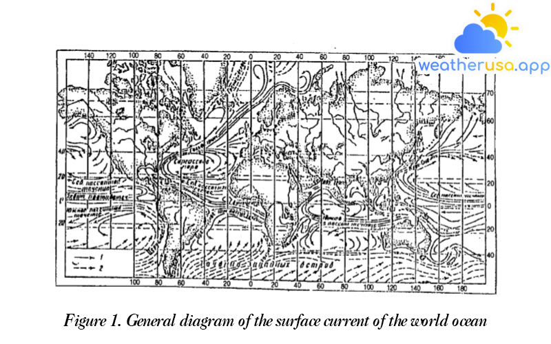
World ocean flow diagram.
General diagram of the surface current of the world ocean
– The main directions of movement of water bodies, averaged from observed data over many years.

Wind action is the primary cause of surface currents in the open ocean. So there is a relationship between the direction and speed of the flow and the prevailing wind. Therefore, we will consider the surface flow maps of the oceans and seas according to the following picture:
a – in the tropical belt of the World Ocean, where the northeast monsoon is observed in the north. sell bridge and east-south – in the southern hemisphere, powerful seasonal westward currents appear on both sides of the equator.
Along the way, when they meet the eastern shores of the continents, the winds create a slope of the water surface and a deviation to the right for the northern hemisphere and to the left – for the southern hemisphere.
Along the way, when they meet the eastern shores of the continents, the winds create a slope of the water surface and a deviation to the right for the northern hemisphere and to the left – for the southern hemisphere.
At latitudes close to 40°, the dominant westerly wind strongly impacts water bodies. Therefore, the direction of the flow is deflected to the east and east-northwest, and later on, its path, when it encounters the western shores of the continents – is deflected to the south in the northern hemisphere and the north – in the southern hemisphere, thereby forming closed loops of currents between the equator and latitudes 40-45°.
In the Northern Hemisphere, some easterly winds are deflected northward when they encounter the eddy arm in the mid-latitudes.
In the Northern Hemisphere, some easterly winds are deflected northward when they encounter the eddy arm in the mid-latitudes.
Lying between the seasonal currents of the northern and southern hemispheres, at the equator, are the easterly counter currents. Unlike the general picture above, the flows are observed only in the tropics of the northern half of the Indian Ocean.
Here, the Indian peninsula and the vast continent of Asia protrude to the south, creating favorable conditions for monsoon development. For this reason, the currents of the northern half of the Indian Ocean have a seasonal course corresponding to the monsoon circulation process.
Here, the Indian peninsula and the vast continent of Asia protrude to the south, creating favorable conditions for monsoon development. For this reason, the currents of the northern half of the Indian Ocean have a seasonal course corresponding to the monsoon circulation process.
b. In the middle latitudes of 45-65° in the northern part of the Atlantic and Pacific oceans, currents create counter-directional eddies.
However, due to the instability of the atmospheric circulation at these latitudes, the Currents are also characterized by poor stability, except for tributaries that are fed by frequent equator-to-pole ocean water gradients, e.g., the North Atlantic and the warm North Atlantic currents Pacific.
However, due to the instability of the atmospheric circulation at these latitudes, the Currents are also characterized by poor stability, except for tributaries that are fed by frequent equator-to-pole ocean water gradients, e.g., the North Atlantic and the warm North Atlantic currents Pacific.
c. At polar latitudes, according to observations of drift ice in the Arctic Ocean, surface currents are directed from the coast of Asia across the North Pole toward the southeast coast of Greenland.
This feature of the flow is, on the one hand, caused by the prevailing easterly winds here and, on the other hand, is compensated by currents from the North Pole.
Westerly currents predominate near the Antarctic coast and form a narrow circulation belt along the beach, running from east to west. And in the seas farther from the shore currents to the east, westerly winds prevail here.
Characterization of the main ocean currents.
a. Atlantic. The north equatorial current of this ocean begins at Cape Blue, which has a generally westward direction. The flow speed varies between 0.5-1 knot in the south and 0.3-0.5 knot – in the northern part.
Towards the small Antin Islands, the current splits: one part goes along the north coast of the islands, forming the Antin Current, and the other part joins the Guiana Current, which runs along the southern coast of America, including the Caribbean Current.
Towards the small Antin Islands, the current splits: one part goes along the north coast of the islands, forming the Antin Current, and the other part joins the Guiana Current, which runs along the southern coast of America, including the Caribbean Current.
- The hot water flows through the Gulf of Florida into the Strait of Mexico to the mouth of the Atlantic Ocean. Here under the name, Florida flow begins the system of hot solid currents of the World Ocean – the Gulf stream.
It is in the bay that the Florida current has a speed of 4-5 knots, and a larger one, near the coast of Florida – 3 knots. - After exiting the ocean, the Golrsdrim Current merges with the Antin Current to form a general northeastward flow along the east coast of the American continent.
- From the north, near the shores of America, a southerly countercurrent carries that cold water down Labrador.
- East of the 46th meridian, the Goltstrim does not manifest itself as a current, weakens, and is divided in the eastern part of the New Faundlen area.
New branches arise northeast and east into the ocean to the islands of Brittany and near the shores of Europe and are known as the North Atlantic Current. - Over the southern Atlantic, closed currents form counter-clockwise currents. The South Equatorial Current of the Atlantic Ocean is a solid and stable tropical current.
It starts on the African coast in the Guiana Strait and gradually moves westward to 10° north latitude. Approaching the southern coast of America, the current has a speed of 2-2.5 knots and splits into two branches.
One major tributary, the Guiana Current, travels along the northwest coast of the South American coast and empties into the Kara Sea. At the same time, the other branch turns south to form the hot Brazilian Current, which has a speed of about 1 knot.
Near 45° S, the current gradually separates from the shore and veers to the east, joining the current with westerly winds. - At the equator, lying between the north and south equatorial currents of the Atlantic Ocean, it creates a low current in the opposite direction, spreading eastward at a speed of 0.5-1 knots. Most of it is called Gvian; the rate reaches 2 bows or more.
- The more southerly side of this western ocean current meets some cold drafts. A cold wind sweeps around Cape Gorn from the south, bringing with it many To the right of the cold water, it divides the Folklen stream flowing north along the coast of South America. The primary Cape Gorn current flows into the prevailing westerly breeze.
b. Pacific. North equatorial currents originate from the central coast of America. It crosses the ocean at 10-20°N with speed no greater than 1 knot.
After reaching the shores of the Philippine archipelago, the North Equatorial Current divides into several branches: one branch in the southwest-south direction along the shores of the Donda Islands, the other unit is first diverted to the south, then to the east, and connects with the northern branch of the South Equatorial Current in the opposite direction.
This flow propagates from west to east between 5 and 10°N at a speed of 0.5 knots and up to 2 knots. As they approach the coast of Central America, the currents divide into a northern and southern tributary, joining the corresponding seasonal flows.
- A major tributary of the north-equatorial current that runs along the east coast of the Philippine Islands and Taiwan and deviates east-northwesterly under the name Kurosio Current is a secondary strong hot ocean current of the Great Ocean World.
Its speed is from 1-2 arcs, sometimes up to 3 arcs. At the transition point near the southernmost tip of Kiusiu Island, the flow divides into two branches: one is directed to the Gulf of Korea as the Xusim current, and the other is the main branch that transmits in the northeast-northeast direction.
Then, as it expands, it turns into the northerly wind of the Pacific Ocean, entering the ocean eastward. Approaching the coast of the Americas, this current splits into two branches: one turns to the south, the other turns northeast-north, and then north to the Alaska Strait, creating the Alaskan current in the form of a vortex. Its speed is 0.5-1 arc. - The Kurosio Current running along the Kurin Islands becomes the unstable cold Kurin current supplied by the Beringov watercourse and the Sea of Okhotsk. The flow rate is about 0.5 bow.
- The south equatorial current, first moving south from the Galapas Islands, has a speed of more than 2 knots.
Still, it gets weaker as it moves west. in the western ocean, this current divides into two branches: from the north, when it meets New Gvian Island, it begins to shift in the west-north direction, then gradually deviates to the east.
The southern branch on the Australian coast is deflected to the south, creating a low-humidity and slow-speed Australian copper flow. - When meeting the southern coast of the Americas, the westerly wind divides into two branches: one branch at first descends south, then east, and the confluence with the head of the Cape Gorn current, and the second branch deviates north with the name of the wind.
Peru, its speed is no more than 1 arc. Traveling along the coasts of Chile and Peru, it enters the Galapas Islands and joins the equator south.
c. Monsoon features determine Indian Ocean Currents of the northern part of the ocean; the current system in the southern part resembles that of the Atlantic and Pacific Oceans.
The south equatorial current, which runs from Australia to Madagascar, shifts southward, its northern boundary at about 10 south longitudes, while the southern border is unclear. The flow rate is close to 1.5 arcs, up to 3 turns maximum.
The south equatorial current, which runs from Australia to Madagascar, shifts southward, its northern boundary at about 10 south longitudes, while the southern border is unclear. The flow rate is close to 1.5 arcs, up to 3 turns maximum.
- In Madagascar, the stream is bisected. The part of the current that goes north along the coast of Africa in the winter in the northern hemisphere does not reach the equator; when it encounters the monsoon, the flow turns into a low flow.
The second part of the north branch turns south to create the hot Modambic current, the average speed of which is about 2 knots and the maximum speed – of up to 4 knots.
At the southern tip of Africa, the Modambic current enters the starting point of one of the hot, strong, and stable ocean currents – the Iron nose current, with an average speed of more than 2 knots and a maximum of about 5 knots.
On the meridian of the iron cape, it deviates first to the south, then to the east, merging with the cold water of the westerly wind at a speed of about 0.5-1 knots. - The southern arm of the south equatorial monsoon flows around the east coast of the island of Madagaska, creating the relatively weak Madagaska Current at 0.5-1 knots, which propagates northwards and merges with the current western cold.
Approaching the Australian coast, the western wind is partly east and partly north under the name of the west of the Australian currency. - The northern part of the Indian Ocean, during the northeastern hemisphere monsoon, usually goes westward. During the winter monsoon in the Bay of Bengal, the current is stable in the southwest-southwest direction; its speed can reach 3 knots.
In the Arabian Sea, the current flows in the West and Southwest directions; when approaching the Somali coast, the speed increases to 2-3 knots, called the Samali current.
As it comes to the equator, this current meets a branch of the southerly monsoon, advancing from the south and turning to the east, creating a countercurrent.
This current cuts the ocean from west to east between the equator and 10° south latitude at a speed of 2 -2.5 knots. Near the shores of Xumatra it rotates mainly southward and is associated with the south equatorial monsoon. - In the summer, on the momentum of the westerly-southern monsoon, the north branch of the south-equatorial current changes direction to the north of Africa along the coast of Xomali; when reaching the equator, the speed is high and stable under the influence of the wind west – south season;
The average flow rate is close to 2 arcs, the maximum debt is – 4 – 5. Between Africa and Ceylon, there is a flow of copper with a speed of 1-2 knots/hour.
West Seychelles to the shore of Xumatra, the eastern sea current speed increases to 3 – 3.5 knots. On the banks of Xumatra, the current deviates southward and connects with the south-equatorial monsoon.
d. Arctic Ocean. A large mass of surface water, which begins around the islands of Novaxibia, moves clockwise from east to west.
In the western part of the ocean, these currents are the starting point of a cold ocean current – the Grenlan and Labradop run together into the North Atlantic. From the Atlantic Ocean, the warm waters of the North Atlantic Common Current and its tributaries approach the Arctic basin.
These strong currents play an essential role in oceanography, climatology, and biology for these micrographs. A large volume of Atlantic water moves northeast along the Skandinav coast.
On the latitude of Cape Nordkap, the North Atlantic Current is split in two. A tributary that flows around Cape Nordkap known as the Nordkap current reaches the boundary of the Barens Sea.
The other, stronger branch continues its course northward and calls the Spixbergen Islands, which are more westerly than the archipelago and are known as the westerly current – Spixbergen.
Others, in the eastern part of the Arctic, exists a system of circular currents caused by the prevailing northeasterly winds.

Weather 01852 - Lowell MA

45°
clear sky
Feels like 43°05:46/19:39
49°F
/42°F
45%
1031 hPa
7 mi
4 mph


