Land Loss Along the Atlantic Coast
A Closer Look: Land Loss Along the Atlantic Coast
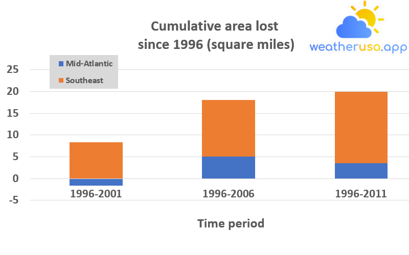
Figure 1. Land Loss Along the Atlantic Coast, 1996–2011

The results were divided into two regions: the Southeast and the Mid-Atlantic. Negative numbers indicate where soil loss is faster than new land accumulation.
| Area | 1996-2001 | 1996-2006 | 1996-2011 |
| Mid-Atlantic | -1.56093 | 5.070951 | 3.545808 |
| Southeast | 8.376642 | 13.02991 | 16.43185 |
Figure 1. Land Loss Along the Atlantic Coast, 1996-2011
Data source: NOAA, 2013
Web update: May 2014
Units: Square miles
Figure 2. Land Submergence Along the Atlantic Coast, 1996–2011
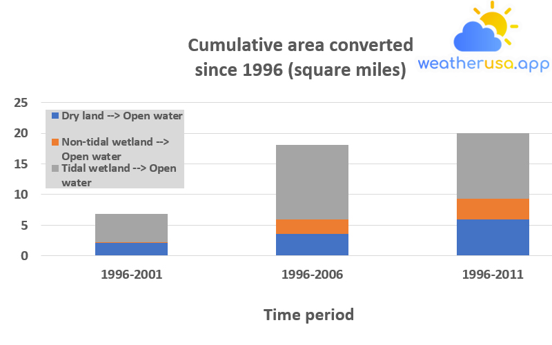
This graph shows the net amount of land converted to open water along the Atlantic coast over three periods: 1996–2001, 1996–2006, and 1996–2011. The results are divided into categories to show the type of land converted to open water.
| Area | 1996-2001 | 1996-2006 | 1996-2011 |
| Dry land --> Open water | 2.06306 | 3.517662 | 5.926476 |
| Non-tidal wetland --> Open water | 0.155329 | 2.374413 | 3.35434 |
| Tidal wetland --> Open water | 4.597319 | 12.20878 | 10.69685 |
Figure 2. Land Submergence Along the Atlantic Coast, 1996-2011
Data source: NOAA, 2013
Web update: May 2014
Units: Square miles
Key Points
- About 20 square miles of dry land and wetlands were converted to open water along the Atlantic coast between 1996 and 2011. This loss occurred more in the Southeast than in the Mid-Atlantic (see Figure 1).
- The data show that at least half of the land lost since 1996 is tidal wetlands. The dryland loss appears to be greater than intertidal wetlands (see Figure 2).
Background
Much of the land along the Atlantic coast is flat and close to sea level—including thousands of square miles of marsh and other productive wetlands, along with many low-lying cities.
In addition, much of the land along the Atlantic coast is sinking, increasing the local impact of sea level rise. The land in North America is still adapting to ice loss after the last ice age, which peaked around 20,000 years ago.
Before that, thick ice sheets covered what is now Canada and the northern United States. All that ice weighed on the land below it but caused the ground further south to swell. After the ice melted and the extra weight was removed, the northern regions began to rise, and the Mid-Atlantic region began to sink.
- Rising sea levels tend to headline during extreme events, such as high tides that caused billions of dollars in damage during Hurricane Sandy in 2012.
However, rising sea levels can also cause damage cause permanent changes to the landscape as it floods the lowlands. The Atlantic coast is particularly vulnerable due to its low altitude and sinking coastline.
- Loss of coastal land can affect many people, as nearly 10 million Americans live in coastal floodplains. Coastal ecosystems are also at risk.
These environments provide habitat for various plants and animals and services that ensure human well-being, from food production to recreation. - Coastal wetlands provide valuable feeding, feeding, breeding, nesting, and resting areas for many species of fish, shellfish, mammals, and birds. They can act as buffers for coastal areas against storm and wave damage.
- As sea levels rise, arid land can turn into wetlands or open water. Existing wetlands may also be threatened as mangrove swamps, mangroves, and other coastal marshes risk being converted into open water.
- The Sea Levels Indicator shows that sea levels are rising overall due to climate change, but the rate of change varies by region and impact. This feature examines land lost to sea level rise along the Atlantic coast from Florida to New York to provide a proper regional perspective.
It is based on satellite data collected and analyzed over five years since 1996. Figure 1 divides the Atlantic coast into two regions for comparison, while Figure 2 shows other land types each other were lost.
About the Data
Notes
- Coastal land change measurements depend on land cover and elevation data, with significant limits on accuracy and precision. Some results are field tested for accuracy.
Coastal land cover data are regularly compiled by the National Oceanic and Atmospheric Administration’s Coastal Change Analysis Program.
They represent the most comprehensive federal government data on land use and land cover in coastal areas.
- Sea level rise is not the only factor contributing to coastal land loss. In addition to the natural subsidence of coastlines in some areas, such as the Mid-Atlantic, a coastal land loss is made worse by human activities such as nautical works and flood control prevents wetland migration or sediment movement; withdrawal of groundwater, oil, or natural gas in some areas; and boat traffic accelerate wetland erosion. Biological processes unrelated to rising sea levels can also cause shoreline erosion.
Data Sources

Weather 01852 - Lowell MA

65°
clear sky
Feels like 64°05:31/19:51
72°F
/58°F
54%
1005 hPa
7 mi
11.5 mph


