For the fourth consecutive day, rain continues to drench storm-battered Florida, turning roads into canals and leaving drivers stranded
For the fourth consecutive day, rain continues to drench storm-battered Florida, turning roads into canals and leaving drivers stranded.
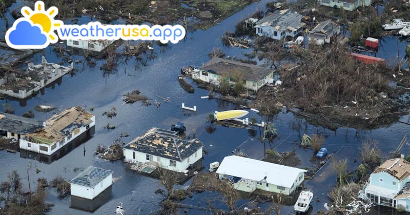
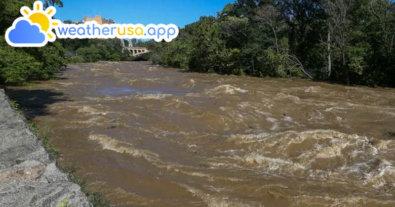
Since Tuesday, heavy rainfall has caused relentless flooding in South Florida, drenching the state for a fourth consecutive day on Friday. The days of deadly, torrential storms have turned roads into canals, forcing some residents to stand on the roofs of their cars or wade through waist-deep waters.
On Wednesday afternoon, a weather-related vehicle crash southeast of Fort Myers resulted in the deaths of a 35-year-old woman and a 25-year-old man. The Florida Highway Patrol reported that their vehicle lost control due to the weather and crashed into opposing traffic, injuring two others.
See more: Weather forecast in 32082 - Ponte Vedra Beach FL
The flooding, which has been waist-deep in some areas, has created hazardous conditions on streets and roadways, stranding drivers and rendering roads impassable. This severe weather has also led to school closures in the hardest-hit counties and caused hundreds of flight cancellations or delays.
With tropical moisture continuing to stream over South Florida, the Weather Prediction Center issued a level 3 of 4 flood threat on Friday, just one level below the rare high risk of excessive rainfall observed on Thursday.

The robust tropical moisture fueling the soaking storms is expected to slowly shift out of the area over the weekend. However, Friday will bring yet another day of heavy rain for South Florida, potentially leading to some cities accumulating over 2 feet of rain by the end of the week. The WPC warned that even moderate rainfall rates are likely to cause additional flash flooding, as any new rainfall will be unable to drain due to the existing flooding.
Flood watches remain in effect for more than 7 million people across South Florida, including in Miami and Fort Lauderdale, through Friday evening. An additional 2 to 4 inches or more of rain is expected through Friday night. While thunderstorm activity is expected to diminish over the weekend, any rain on Saturday or early Sunday could exacerbate the ongoing flooding issues.
Florida Governor Ron DeSantis has declared a state of emergency for Broward, Collier, Lee, Miami-Dade, and Sarasota counties. Officials have urged residents to stay at home and avoid walking or driving through floodwaters, which have inundated streets and homes. Many cities are distributing sandbags to residents to help combat the rising floodwaters.
Flooding has brought familiar dangers back to Florida residents
Since Tuesday morning, heavy rainfall has deluged South Florida, with social media footage showing water levels reaching vehicle windows and flooding parking decks and neighborhood streets.
Weather Forecast For 32083 - Raiford FL
Many South Florida residents, who had just finished repairing their homes after the catastrophic flooding in April 2023, now face water lapping at their doorsteps once again.
In Miami, videos captured stranded cars nearly submerged underwater, and one family's yard resembled a lake, with belongings floating outside and being retrieved from the standing water, according to CNN affiliate WSVN.
"I'm scared," 11-year-old Somaya Ferdinand told WSVN as she waded through thigh-high water outside her home in Northeast Miami-Dade. "It looked like a swimming pool."
In Hallandale Beach, just north of Miami, footage showed a man kayaking among cars as high waters flooded parts of the city. Some mobile home parks were underwater, according to Broward County Sheriff’s Office Fire Rescue Battalion Chief Michael Kane.
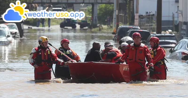
Severe flooding on Wednesday covered cars up to their windshields, forcing some drivers to abandon their stalled vehicles and wade to safety, while others had to be rescued.
"We had to use our boats to rescue people standing on top of the roofs of cars," Kane told CNN, noting that his office received 175 calls for help in Hallandale Beach alone.
In the Broward County neighborhood of Edgewood, resident Anna Rysedorph prepared for the worst as water circled her ankles inside her home. Weather Forecast For 32084 - Saint Augustine FL
"I put the dogs in, I'm all packed up. I pretty much got everything in bins and we're ready to go," Rysedorph told CNN affiliate WSVN. "My husband's like, 'Don't panic, don't panic,' but you know, I'm not gonna be caught unprepared."
Severe storms to impact High Plains, Northeast, and Mid-Atlantic on Friday
While Florida deals with severe flooding, a new severe thunderstorm threat is emerging for the Northern and Central High Plains and parts of the Northeast and Mid-Atlantic on Friday.
The National Weather Service expects thunderstorms to develop in parts of Colorado, Nebraska, and Kansas starting Friday afternoon and continuing into the evening. The main threats in these areas are large hail and damaging wind gusts.
In the East, severe thunderstorms are predicted to form over western Pennsylvania on Friday afternoon and move into the Northeast and Mid-Atlantic Coast during the evening. These storms pose a threat of damaging wind gusts, and some may also bring hail. See more: Zipcode in 32085 - Saint Augustine FL
Major I-95 cities, including Washington, DC, Baltimore, Philadelphia, New York City, and Boston, could be in the path of these strong storms.
Weather 01852 - Lowell MA

40°
clear sky
Feels like 40°07:01/17:59
43°F
/37°F
81%
1025 hPa
7 mi
0 mph