A major flood outburst from Mendenhall Glacier in Alaska would not have been possible without climate change
Between August 4 and August 6, 2023, an outburst flood from a glacial meltwater lake released record amounts of water into Mendenhall Lake and down Mendenhall River towards Juneau, Alaska.
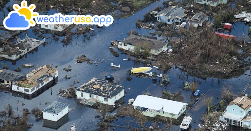
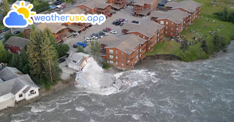
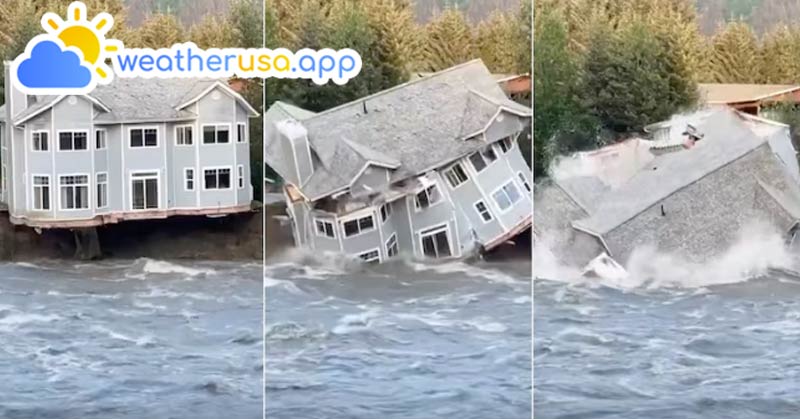
The National Weather Service (NWS) office in Juneau reported significant flooding in areas along the river that had not previously experienced such events. The floodwaters caused substantial erosion, sweeping trees and buildings into the river.
"Decades worth of erosion happened in one weekend," Rick Thoman, Alaska Climate Specialist at the Alaska Center for Climate Assessment and Policy, told Climate.gov. "The buildings that fell into the river and those now uninhabitable were not right next to the river on Friday afternoon."
See more: Weather Forecast For 35011 - Alexander City AL
On August 5, around 11:15 PM AKDT, the Mendenhall Lake gauge crested at 14.97 feet, surpassing the previous record of 11.99 feet set in July 2016 by nearly 3 feet. This exceeded the initial forecast of 12.3 feet from the Alaska-Pacific River Forecast Center, in coordination with NWS Juneau.
At the peak of this event, the United States Geological Survey (USGS) gauge at Mendenhall Lake recorded a streamflow of 25,200 cubic feet per second (cfs), which Andrew Park, a meteorologist at NWS Juneau, described as "historic." According to USGS data, the previous maximum streamflow reached only 16,300 cfs in 2016.
Park put the numbers into perspective, explaining that a streamflow of 17,100 cfs has a 1% chance of occurring in a given year, while a streamflow of 26,000 cfs has a 0.2% chance of occurring in a given year, based on data from a 2020 FEMA flood insurance study.
Climate and Average Weather Year Round in 35013 - Allgood AL
An event with only a 0.2% chance of occurring annually is sometimes called a "1-in-500-year flood." However, this does not mean such events happen only once every 500 years. Instead, it means that over long periods, the average return frequency would be once every 500 years. The flooding following this outburst was equivalent to a 500-year event in the Mendenhall Valley.
Climate Change and Glacier Retreat in Alaska
Alaska has warmed twice as fast as the rest of the United States over the last several decades. Over the past century, Alaska’s average annual temperature has risen by 3.1 degrees Fahrenheit, and this upward trend continues, according to data from NOAA’s National Centers for Environmental Information.
Scientists attribute the retreat, melting, and thinning of glaciers over the past century to Earth’s warming climate. Alaska’s glaciers are among the fastest-melting in the world and have been in steep decline since the late 1980s, according to the Alaska Climate Science Center (AK CSC).
Not every retreating glacier in Alaska is at risk for glacial lake outburst floods, but those that are can have serious downstream consequences. These floods can happen in different ways, but all begin with a lake of meltwater or rainwater runoff blocked by an ice dam. When the dam breaks, the lake can suddenly drain in a massive pulse.
For the Mendenhall Valley, glacial lake outburst floods are relatively new phenomena but have become a yearly occurrence since 2011, when the first outburst occurred. Zipcode in 35014 - Alpine AL
Over the past century, Suicide Basin has changed drastically due to thinning, melting, and glacial retreat. Suicide Glacier, once much larger, was a frozen tributary that flowed into and merged with the Mendenhall Glacier. The photo below, from the Alaska Climate Adaptation Science Center (AK CASC), shows how Suicide Glacier has shrunk over 125 years, from 1893 to 2018.
Changes in Suicide Basin and the Impact of Climate Change
The photo also shows a large valley or bowl, known as a topographic depression, carved out of the mountainous area where Suicide Glacier once was. This bowl now contains leftover ice from the glacier’s retreat, ice from calving events of the Mendenhall Glacier, and additional water that drains into the basin.
Throughout the warm season, snowmelt, rainfall, and glacial meltwater fill the depression within Suicide Basin, which is naturally dammed by the Mendenhall Glacier, creating a glacial lake. Outbursts occur when this water and ice, dammed by the Mendenhall Glacier, are suddenly released and flow downstream.
Although human-caused global warming is the reason these floods occur, many other factors determine when and where a given year’s flood will happen and how big it will be.
See more: Weather forecast in 35015 - Alton AL
Monitoring and Predicting Glacial Lake Outburst Floods in Alaska
Since 2011, scientists from NOAA’s NWS, the University of Alaska Southeast, the USGS, and the city of Juneau have been investigating the region to determine how much water the basin can hold, when the dam gives way to these outbursts, the frequency of these events per year, and their downstream impacts. Similar research is underway in many other Alaska watersheds that now harbor glacial lakes.
As of August 9, 2023, Suicide Basin has started to refill but remains at very low levels, according to the NWS. Scientists will continue to monitor the conditions within the basin as it fills into the fall season. Just last year, there was a secondary release from the basin in October, noted by the NWS. See more: Weather 35016 - Arab AL
Scientists are still actively conducting surveys as this area continues to change, and a post-event survey will be released in the coming weeks. Keep checking back for additional updates as scientists’ understanding of the event evolves.
Weather 01852 - Lowell MA

82°
clear sky
Feels like 82°06:26/18:53
85°F
/80°F
38%
1024 hPa
7 mi
4.61 mph