Typical atmospheric parts and weather in them - P2
Tornadoes forward
Knowledge of tornadoes
- This section describes in more detail the many aspects of cyclones, their formation, and development at mid and high latitudes, commonly known as temperate cyclones, or simply cyclones, and at low latitudes – tropical cyclones. About tropical cyclones will be introduced in a separate section later.
- Cyclone is a closed, low-pressure area with anti-clockwise air movement in the northern and clockwise in the southern hemispheres. On weather maps, it is represented as a secure homologous system with a barometric minimum in the center.
Thus, the horizontal barometric gradient is towards the center of the storm. Cyclones have the most significant atmospheric angle and excellent wind speed compared to other barometric systems. In deep, well-developed cyclones, wind speeds near the center can reach 60 – 70 m/s or higher.
This is especially common during tropical storms. At the storm’s center, the barometric gradient is zero, and the wind speed is negligible; this area is called the “eye of the storm.” - The pressure at the center of mid-latitude cyclones typically ranges from 990 to 1005 mb, but can drop as low as 930 mb… For example, the deepest North Atlantic cyclones are often found near the north coast. America on the coast of Grenlen and the islands.
In the Pacific Ocean – in the area near Japan’s coast- the islands of Kurin, Xakhalin, and Kamtraka. Lots of deep cyclones in the Gulf of Alaska and the Bering Sea southern hemisphere – areas near the coast of Antarctica where a large number of hurricanes are commonly observed, with pressures lower than 950 mb. - The width of mid- and high-latitude cyclones is usually in the range of 1000-2000 km. The longitudinal surface thickness is much smaller – several kilometers.
Occasionally, depending on the intensity and phase of the broadcast, they can reach heights of 12 – 20 km. In the early stages of development, tornadoes do not get 3 – 5 km. - The frequency of tornadoes and their depth depends on the time of year and the subsurface state. In the oceans of the northern and southern hemispheres at middle and high latitudes, they are usually found during the winter period. On the continent, on the contrary, there are more summers than winters.
- In a cyclonic system, under the influence of a gradient force, the gas molecules gradually move toward its center. Still, under the action of the Coriolis force, they are deflected to the right – for the northern hemisphere, and when there is no magma close, they will move along the isobaric line.
In actual conditions, under friction force, the motion trajectory of gas molecules has the shape of a spiral, converging to the center. In a tornado, air near the ground moves into the center and is gradually lifted, i.e. airlift and water vapor condenses.
When there is enough moisture, clouds will form, and precipitation will decrease. Therefore, the central area of the cyclone is characterized by overcast weather and heavy rain. - In the middle and above the troposphere are clouds of tornadoes, the air escaping.
- The line connecting points of minimum pressure at different levels is called the vertical axis of the cyclone. It inclines – due to the height of the hurricane’s center being deflected toward colder air.
Formation and evolution of a tornado.
- In the earth’s atmosphere, cyclones’ formation, development, and loss are constantly occurring. Their lifespan ranges from a few hours to a few days.
The atmosphere always creates different conditions; some conditions allow tornadoes to develop, while others prevent development. - Cyclone – it is not only an area of low pressure but also a unique vortex of atmospheric circulation. Therefore, when considering the causes of its formation, it is necessary to view many processes occurring in the atmosphere.
At present, many theories about the appearance of vortices are proposed. Still, they cannot fully explain their development due to their complex magnetism, only one or a few just some of factors. - Depending on the characteristics of formation and development as well as different geographical areas, people are divided into extratropical cyclones and tropical cyclones. Extratropical cyclones are subdivided into frontal and non-frontal cyclones.
- The vortex is not face-to-face, usually associated with uneven heating of the subsurface and also associated with the presence of a local decompression furnace. Heat cyclones typically occur in winter over the Black Sea – the warm waters and cold continents surrounding it.
- We now consider the formation and development of front cyclones. This type usually forms in middle and high latitudes.
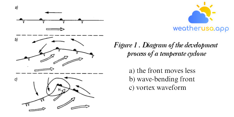
- Assume that there are two adjacent groups of air, with the same travel speed, along a less moving facade (fig. 1). Due to the influence of several reasons, there is an uneven variation of the barometric pressure over the front band.
The airflow of the two air groups changes direction creating two forward and reverse circulations. The part of the front that didn’t move much started to break the waveform (fig. 1b).
When a large horizontal thermal gradient exists in the middle of the troposphere, the wave bending of the front will increase. The hot and cold parts of the front will appear wavy (fig. 1c).
The hot air begins to penetrate the cold air, and the cold air penetrates the hot air. The pressure drop continues, leading to the formation on the ground of the isoline being closed and forming a forward helical current. - Terrestrial cyclones are generated mainly on cold fronts that are less moving and near the confluence of storms as follows:

1) Wavy phase. Bend formation is associated with fracture of the less mobile front face, with hot and cold segments on it. On a terrestrial weather map, a tornado takes the form of an isobaric Juvenile Cyclone Stage (see figure.1c).
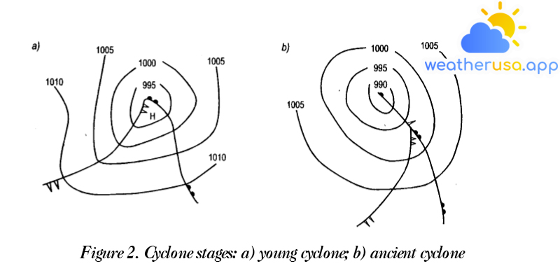
On terrestrial weather maps, tornadoes often form several closed isobars. Spiral circulation is sometimes observed at an altitude of 3 – 4 km. (on the 700 mbar isobaric surfaces, there are closed curves).
3) The turbulent cyclonic phase (fig. 2b). At this stage, the cyclone reaches its highest development and begins to be perfected. The cold front moves faster than the hot front, overwhelming the hot air and approaching the hot front.
The hot (fan low) area gradually narrows and comes to a point when the confluence of the cold front and the hot front occurs, that is, the convergence of the cyclone. At this stage, many closed isobars are drawn on the weather map.
Closed circulation is discovered at an altitude of 3-5 km, sometimes even higher. The axis of a cyclone is usually tilted to the west – north, or west.
That process is started on the ground. The middle and upper cyclonic troposphere may still be undeveloped for some time.
According to the depth of the hurricane, the cold front, on which the wave bending occurs, shifts southward. Therefore, each subsequent branch cyclone will move in a southerly and faster orbit than the previous one.
The weather changed markedly: cloud systems formed, the wind increased, rain intensity increased, and visibility decreased; The direction of the tornado was altered, and the speed of movement increased. This is related to the appearance of excess energy in this area.
In the Pacific Ocean – in the vicinity of Japan, Kurin Island, and Aleut Island, near the shores of Kamtraka. Cyclone reconstruction is also seen in the Bering Sea and Alasca Bay.
Displacement of vortices
- Since their appearance, tornadoes have moved in the direction of mid-troposphere currents. Because of the general displacement of air in the troposphere, which occurs from west to east, most tornadoes are displaced in that direction.
However, they rarely follow exactly along latitude because the troposphere is often systematically tilted away from the region. On average, tornadoes move from west to east, from lower latitudes to higher margins. - General statistics of all factors affecting certain circulation conditions to the movement of cyclones can only be done in specialized methods and calculations, often used in weather forecasting.
- At first-order approximation, it can be assumed that the formation of all barometric fields in the next 6 hours is the same as yesterday. During this cyclonic phase, their displacement occurs along the isobaric line of the hot zone.
The turbulent eddy moves perpendicular to the direction of the maximum horizontal barometric gradient and deviates to the right. The velocity of a cyclone depends on the airflow rate in the middle troposphere. - The average speed in the Northern Hemisphere is about 30-40 km/h, while in the Southern Hemisphere, it is 42-45 km/h.
Weather in tornado
- The front and center part of the tornado distributed in cold air. Stable weather characteristics are determined by the neighboring conditions of the hot front: with the existence of a cloud system: Ci, Cs, as, Ns and a lot of rainfall over a large area, the wind strengthens with the opposite direction clockwise in the northern hemisphere or clockwise in the southern hemisphere; Visibility is reduced to 2 knots.
- The hot zone lies between the hot front and the cold front. The weather conditions are different from the above area. The burning front cloud system disappeared, the rainfall stopped falling, and the wind weakened.
Cloudy, overcast weather can be observed in the hot seas in summer. Winter is cloudy with Switzerland and Scotland, cloudy showers, and cold. Visibility is reduced in blind conditions not less than 200 m. The front road is hard, often with showers, thunderstorms, and strong winds. - Post-cyclonic close to a cold front. The cold front determines weather characteristics: there exists the order of clouds Ns, as, Cs, Ci. In front of the front can see each type of cloud, Cc, Ac, and separately, when the front comes – Ns clouds, below it, in the front area with moderate rain.
After the cloud system, a marked decrease in cloud patterns can be observed. It is possible to develop accumulation clouds such as Cb and Sc with a precipitation barrier in the cold air group located quite far from the cold front.
In the forward area, unlike intensification, gusts often occur along the very front. Visibility is good, in average water from 200 to 400 m.In a cyclonic confluence, a cloud system of hot and cold fronts combines, accompanied by many precipitations, lousy visibility, and robust winds.
Weather conditions at the center and front of the confluence may differ slightly from those of the latter, depending on the magnitude of the difference, like the air forces on either side of the front prison neck.
Before the storm front, the cloud system of the hot show is still preserved, and there is average rain after the storm front – showers related to cumulus clouds.During a complete tornado, frontal erosion occurs, clouds disperse, precipitation is possible only in some places, visibility is improved, winds are weak, and weather conditions in all areas parts of the tornado are almost the same.
In the barometric trench, weather conditions are determined by the characteristics of the front, its distribution, and depth. For example, if the barometric trough represents a hot zone, the weather conditions would be characterized by a Ci, Cs, as a cloud system.
NS, there is a lecture on regular water, stronger wind, there is blind. The further away from the cyclone and the less visible the barometric trough, the less visible the hot front: small water shape, slight increase in wind, and variable cloud characteristics.
Cloud system Ci, Cs, as, Ns is gradually broken butt, Sc appeared, and Ns clouds disappeared. The part of the hot front in the barometric trough is poorly represented, often firmly erased, followed by stratospheric clouds near the front, easily confused with Ac clouds. In that case, it can only be distinguished by slight rising winds and weak glare.In slow-moving barometric troughs, along with cold fronts, mainly Cs, as, Ns clouds are formed with precipitation in the posterior part of the trench. However, there is also the possibility of clouds and rain on both sides of the cold air.
Usually, in the front part of the trench, due to active convection, cumulus clouds appear, while the as, Ns cloud system is absent. In fast-moving troughs, clouds are usually formed in their front part, directly in front of the cold front.
After the cold front, there are often showers. Winds in trenches with cold fronts are usually solid and intermittent.
The change in meteorological factors during the passage of the cyclone.
- When crossing the viewpoint by the southern part of the cyclone – the weather changes in proportion to the passage of the warm front, the warm zone, and the cold front, which have been represented above, if the cross-section of the cyclone is located at a considerable distance from the center, the characteristic cloud system and the de-precipitation of the warm front may not be the case.
This is related to cloud formation and precipitation. Passing further south, variable cloudy or cloudy weather can be observed, with no rain and no fog. - The passage of the observation point of the middle part of the cyclone, with the peak of the hot zone. In this case, the approach of the hurricane will initially be characterized by a slight decrease, followed by a substantial reduction in pressure.
After passing through the center of the vortex, the pressure drops a little, then gradually rises. The thick cloud zone of the Ci, Cs, as, Ns system is wider than the passage of the region of hot air, so there is a lot of precipitation and a long time.
The selection of a cyclone is accompanied by a decrease in the wind, sometimes a calm, then a sharp increase in the wind. The air temperature drops slightly. Visibility is relatively poor at 2-4 knots, in rainfall less than 2 knots. - When passing the belvedere, the northern part of the cyclone is shown on line CC figure 3. In this case, the weather change is almost the same as in the central region. However, the head loss is lower, and the precipitation area is smaller. The wind direction changes counterclockwise.
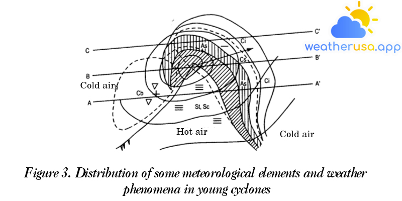
Figure 3. Distribution of some meteorological elements and weather phenomena in young cyclones
Vortex tropics
General concepts
- Cyclonic activity is not only observed at mid and high latitudes. Usually, there are many cyclonic disturbances at low margins, but they are less pronounced.
The pressure in the center is only 1-2 mbar lower than the surrounding area, the wind is weak, and they are moving slowly from east to west. But these disturbances develop into deep tropical cyclones, with significant pressure gradients and stormy winds. - What is a tropical cyclone? It is a region of small-scale but deep spirals, generating significant kinetic energy; the barometric gradient developed in tropical cyclones is the largest compared to other barometric systems. According to him, the wind speed is also the strongest.
- In our country, tropical cyclones are also called tropical storms. In many other countries, they are called by many different local names. For example, in China, it is called “Typhoon”; in Australia, Willy – Willy, in the Caribbean Sea-Hurricane.
These names are united under a common designation “tropical depression.” The term “tropical cyclone” refers to all cyclone’s winds with the lowest pressure in the center.
Formation of tropical cyclones
Zone of generation of tropical cyclones
As per observational data from artificial satellites, there is a vortex-generating tropical climate in Africa.
But to develop into a strong storm only on the surface of the sea.
Table 1. The seas are subject to tropical cyclones and their names.
| Waters | Nameplate | Main season | The most month |
| West – North Pacific | Typhoon | June-November | July, August, and September |
| Northeast Pacific Ocean | Hurricane | June-November | September |
| South Indian Ocean | Xiclon | November – April | January and February |
| West – North Australia | Willy-Willy | December-April | January and February |
| North Atlantic | Hurricane | June-November | September |
| Arabian Sea and the Bay of Bengal | Xiclon | April-November | June, July, October, and November |
The main track and mean displacement of tropical cyclones.
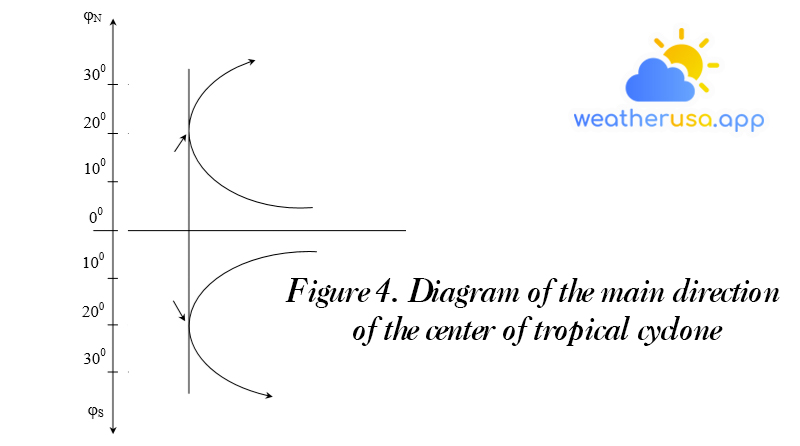
- Tropical cyclones generally move west, then northwest, at low speed. This direction is dominated by a constant flow of tropical air from the east. Later, at higher latitudes, tropical cyclones’ movement rate increases to 30-40 km/g and more than.
- In the latitude belt of about 15-30°, tropical cyclones change direction, moving north and even northeast in the northern hemisphere or south and then east-south in the southern hemisphere. Figure 4 shows the main principle of the tropical cyclone’s center in the north and southern hemispheres.
- This is only a general diagram of the direction of the tropical cyclone’s center. This is not always the case, but very erratic. The complex diversion of tropical cyclones depends on the general distribution of barometric pressure, which persists during this period.
- This direction of travel generally tends to curve around a subtropical anticyclone.
- An area of high pressure, which can impede the movement of a tropical cyclone when its intensity is large enough, can cause a change of direction. The seasonal migration of subtropical high-pressure areas causes the inflection point to move appropriately north or south relative to its mid-latitude.
Figure 5 shows typical tracks of tropical cyclones, according to which it is possible to identify the seas that often generate them. As it reaches mid-latitudes, the hurricane gradually fills up and slows down.
However, in an encounter with colder air, it is revived, leading to its deepening, the acceleration of its movement, and the widening of the cyclonic zone… And like extratropical cyclones, they can move to higher latitudes. When it reaches dry land, it quickly weakens and fades.
Weather in tropical cyclones
Depending on the stage of development of tropical cyclones, the weather conditions are also very different. Depending on the wind speed in the near center, people divide tropical cyclones into 4 main categories:
- Tropical depression with wind speeds below 17 m/s (below 33 knots) or subgrade 7
- The moderate tropical storm, with wind speed from 17: 24 m/s (from 33: 47 knots) or from level 8-9.
- A strong tropical storm with a wind speed of 25: 32 m/s, or level 10: 11.
- Storm extremely strong tropical with wind speed above 32 m/s, level 12 above. Here are the meteorological manifestations in the stages of development of tropical cyclones:
- Phase of tropical depression; denser clouds, cumulus clouds, and Ti clouds. On the weather map on the ground, several closed isobars are displayed. The eastern area has local showers; the wind speed here reaches 17 m/s, while the wind speed is lower west of the low pressure.
– During the tropical storm period, a very dense system of accumulators existed. The thick cloud system begins with a spiral, followed by spiral bands converging at the center along currents, on the weather map – some concentric closed isobars and large barometric gradients.
Appearing showers, with great intensity in the east and northeast-north of the cyclone, with thunderstorms, strong winds, and extended storm winds.– Strong and powerful storm phase – there is a dense disc-shaped convergent cloud system with a sharp outer edge; cumulus spirals are scattered away from the central mass in the center.
Usually, a dark area can be seen in the center of the cloud mass, called the “eye of the storm” – the sky is clear and cloudy. On a weather map – a system of double concentric closed isobars; many barometric gradients of up to 15-20 mb over 1° meridians.
The wind speed is raised to the maximum value. The waves are very violent and messy. Storm characteristics can last up to 5-7 days.– The disintegration phase of tropical cyclones – gradually loses the characteristic features of the distribution of clouds, rain, and wind. The thickness of the Ti cloud decreases and partially disappears, the central disc-shaped cloud mass disintegrates, and there is no clear outline on the outer edge.
On the weather map, the number of closed isobars decreases, the barometric gradient becomes weak, and the wind is soft.
Signs of approaching tropical cyclones
Ship operators operating in sea areas where tropical cyclones are likely to encounter should take care to monitor changing weather conditions to detect their approach early and anticipate possible consequences.
Signs of approaching tropical cyclones can be the following phenomena:
- The appearance of surge waves coming from a direction does not coincide with the actual movement of the wind. Large waves move faster than tropical cyclones; when this wave is observed, the hurricane’s center is 400-500 nautical miles away.
Off the ocean, the direction of wave propagation approaches the direction of the cyclone’s center. However, when there are islands near the shore, the wave direction no longer points to the tropical cyclone’s location. The closer the typhoon, the more intense the sea surface becomes. - The initial barometric pressure decreases slightly, then decreases more sharply.
- The appearance of Ti, Ti clouds clustered at one point on the horizon indicates that a tropical cyclone is about to come from there. After the Ti clouds – rain clouds – thick cumulus clouds appear. The intensity of the wind increases gradually.
- The intense atmospheric discharge causes significant interference in radio receivers. The most vigorous discharge intensity is observed in the direction of the cyclonic position.
- The color of the sky sparkles at dawn and dusk.
Therefore, it is necessary to monitor and observe weather changes; marine weather forecasts and storm forecasts are broadcast from ship weather service facilities by radio receivers, using radio receivers’ fax machines,s and other radio receivers.
It is also necessary, even when the tropical cyclone is still very far from the ship, and must consider the possibility of changing its direction and speed of movement.
The captain’s action
Before deciding on an action to avoid a cyclone, the captain must know: the azimuth and, if possible, the distance to its center, the semicircle in which the ship is located, and the potential trajectory of the tropical cyclone.
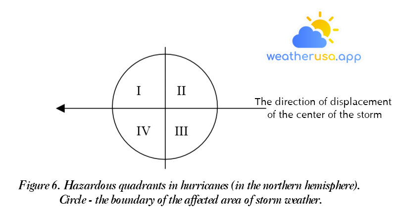
- The most dangerous quadrant is located in the right and left front corner because ships are pushed into the center of the storm by waves and winds. This is also where the heart of the battery will come from.
Located to the left of the northern hemisphere and the right of the southern hemisphere concerning the direction of the storm center is called a semicircle because here, the position of the storm center tends to move away from the part of the ship.
- When the ship is away from the storm, the area with the center of the battery can be determined according to the Buy Ballot rule.
The content of this rule is as follows: if you stand with your back to the wind, the area with the center of the storm is on the left for the northern hemisphere, and the right front, for the southern hemisphere.
Also, it is necessary to observe the wind and measure the barometric pressure to determine the semi-circle in which the ship is moving. The monitoring results show that the vessel is in one of the following cases:
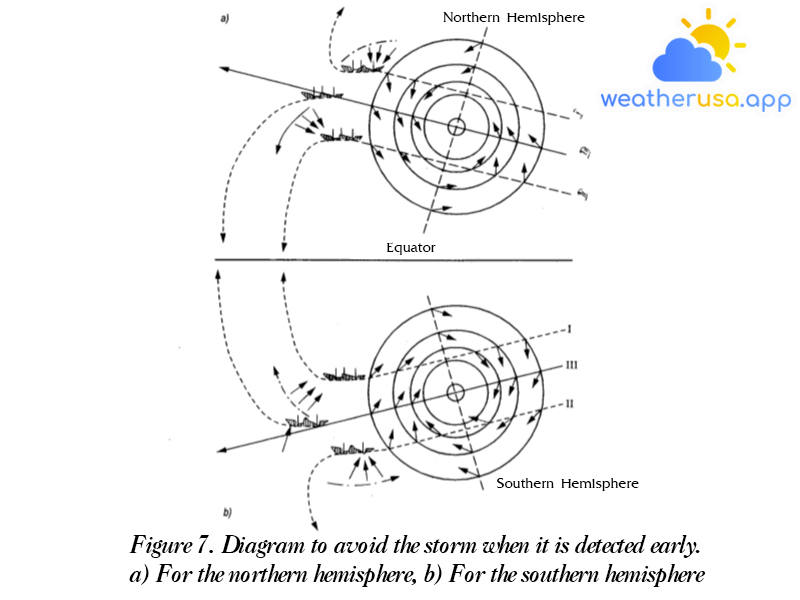
- If the barometric pressure decreases, the wind increases, and the wind direction gradually deviates to the right, the ship approaches and to the right of the path of the storm’s center (Figure 7, a, b position I).
- The same conditions, but the wind direction is shifted to the left, indicating that the vessel is approaching and to the left of the storm center track (Figure 45 a, b, position II).
- If the wind direction remains constant while the pressure decreases and the speed increases, the ship will approach and be on the correct course toward the center of the storm (Figure 7, a, b, position III).
It should be remembered that the direction of the wind is inclined concerning the tangent of the outer circular isobar at an angle of approximately 45° and the closer to the center of the storm, the smaller the angle of inclination at the innermost isobar, the direction of the wind approximately coincides with its tangent.
The dashed line indicates the direction the train needs to go.
a. For the Northern Hemisphere: in case the train is located to the left or right of the center of the storm: positions II and III, it is necessary to change the train’s running direction so that the wind blows to the right.
And when the ship goes to starboard, the boat must be guided so that the wind blows to the right.
b. For the Southern Hemisphere: If the ship is located on the right or right side of the storm center, it is necessary to change direction so that the wind blows to the left.
And when the train is moving to the left, the train must be guided so that the wind blows to the left.
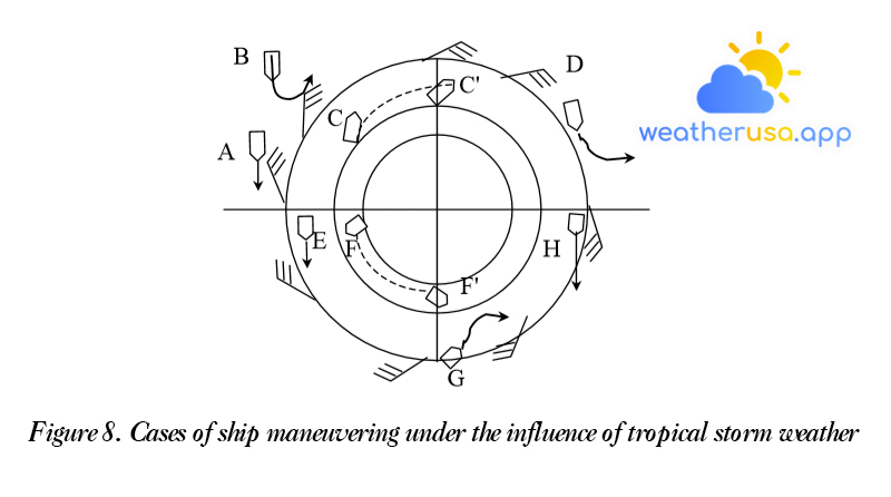
- Scenario A: Vessels near the most dangerous quadrant that can confidently pass before the center of the storm need to keep the wind to the right and keep the ship’s direction perpendicular to the center of the battery to overcome the cargo vortex sea completely.
- In the case of B, if it is challenging to pass before the storm, it is necessary to change the ship’s direction so that the wind blows to the left and gradually retreats away from the storm’s center.
- In the case of C, it is impossible to go far from the storm’s center, and the ship must be kept in the opposite direction by operating the engine at full power.
- Case D. When the ship is in quadrant II, it is advisable to turn left and let the wind blow to the right.
- Case E. The ship is located in part IV; let the boat go straight to gradually move away from the center of the storm; at this time, the wind blows to the right.
- Case F. The ship is on the left before IV but near the center of the storm and cannot keep the direction perpendicular to the storm’s path, so keep the ship’s direction so that the wind blows to the right and keep that direction until the center of the storm passes.
- Case G. The ship is in the third quarter, changing direction to the right, so the wind blows to the left.
- Case H. The ship is pushed behind the center of the storm, in a floating state, letting the wind blow to the left and keep it like that until the storm’s center goes away.
After the maneuver is complete, it is still necessary to continue closely observing the weather changes in the area of the ship’s operation to promptly correct and change the maneuvering method.
Reverse vortex
General awareness of anticyclones
- Anticyclone is an area of high pressure with closed isobars. Air in a cyclone moves clockwise in the northern hemisphere and counter-clockwise in the southern hemisphere.
The barometric gradient in the vortex is directed outward from the center. Winds in the center of the cyclone are weak, sometimes intense, and in the periphery – stronger. The most robust wind speeds usually occur in front of anticyclones.
- The pressure at the cyclone’s center varies between 1010 and 1040 mb. The barometric pressure for the Siberian winter storm is as high as 1080 mb.
Retrograde vortices can cover a huge area, often commensurate with the continent’s size.
- The frequency and intensity of cyclones depend on the year’s season and the subsurface’s state. On continents, storms are more potent in winter, in mid- and high-latitude oceans in summer, and subtropical regions of both the northern and southern oceans. Hemisphere – in August and September.
- In the anticyclonic system introduced, under the effect of a gradient, the gas flows move in the form of a spiral radiating from the center to the outside.
So, in its central part, the downward flow of air from the upper layers of the troposphere is observed. The “deposition” of thick gas layers leads to dynamic heating and the creation of thermal inversion.
Therefore, in the central area of the cyclone, the weather is often cloudy, dry, and windy.
The formation and displacement of cyclonic countercurrents
- The formation of cyclones is also due to causes such as the formation of cyclones. For their formation, factors that lead to an increase in atmospheric pressure and the formation of vortices of the barometric field near the ground and the troposphere are required.
- The formation and development of the cyclonic circulation are closely related to the development of the vortex. But if in the process of building and development of cyclones, the dominant role of atmospheric fronts, then in the anticyclones, they do not bring the action.
Reverse eddies are created in homogeneous air groups. They usually occur in cold air, not far from the front lines on the ground. - The retrograde and cyclonic vortices, commensurately shifting, are in the same direction as the mid-troposphere flow.
The order of movement of young cyclones mainly coincides with the direction of air currents at an altitude of 3-5 km. As they grow, the speed of movement of anti-vortexes slows down, and they often become less moving objects. - The average travel speed is 25-35 km/h. Retrograde vortices mainly move from west to east, roughly south, concerning the northern hemisphere and north to south, i.e. their orbits tend towards lower latitudes.
The polar vortex has a distinct direction from west-north to east-south in the northern hemisphere called a retrograde vortex. The erosion of cyclones from the north, or from east-north to south or east-southeast, is called polar cavitation.
The weather is in a tornado
- For the central part of the cyclone, the weather is characterized as dry and cloudy with fairly straightforward day-to-day heat variations.
Depending on the characteristics of the air group, during the generation of the cyclone, and the features of the underlying surface, the anticyclone may contain the following conditions: different weather.
For example, under the inversion layer, thick St and Sc clouds and even drizzle can be observed during the cold season of the year. Radiation blindness often occurs, making it difficult for ships to navigate. - In the periphery of the circulation, the weather conditions differ from the central region. They are usually determined by the weather characteristics of the area approaching the surrounding tornadoes.
- The eastern part of the circulation, bordering the back of the cyclone, can see the formation of Cu, Cb clouds, and showers. Sc clouds also often appear, created from the fragmentation of Cb clouds.
- In the western part of the retrograde, a Ci cloud may appear, which is a precursor to the approach of the hot front. Here we can see bad weather, with moderate rainfall over a large area and clouds of the secondary hot front.
- The western periphery of the anticyclone, especially the low-moving type, is characterized by winds of magnitude 6-7, sometimes even more significant.
- For the northern part, there exist thick or relatively thick St and Sc clouds. It is not uncommon to have fog.
- In the southern part of the anticyclone, clouds of Ci, Cs, and as are visible. Strong winds often appear.
For example, in winter, due to the sizeable barometric gradient on the southern periphery of the cyclone, strong storm winds are observed in the northern part of the Black Sea. - In the barometric vanes, weather conditions vary widely, but there is almost no wind, no rain, and occasional radiation haze.
Atmospheric circulation over different regions of the globe
The concept of the general circulation of the atmosphere
- The uneven distribution of solar radiation over different latitudes.
- The day-night movement of the earth generates the coriolis force.
- The heterogeneity of the buffer layer, i.e. the division of the earth’s surface into continents and oceans.
A simple diagram of the general atmospheric circulation.
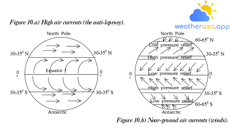
- To consider a proper cycle of the earth, we must first assume that the earth’s surface is homogeneous.
Thus the absorption of solar radiation by the buffer and by the air will be the same over the same latitude, and assume that the earth is not rotating but stationary!
- At low latitudes, most of the year, where the sun’s rays are vertical, the surface receives the most solar energy, and according to it, the air temperature here is highest compared to above middle and high latitudes.
That leads to a surface depression on either side of the equator. Hot air here will rise to compensate for this equatorial belt; from the regions near the poles, there will be air currents close to the ground, moving towards the equator, in the direction of meridians, making gas pressure decreases from the poles towards the equator.
In the upper layers, air currents move from the equatorial belt, toward the poles, in the direction of meridians. Thus: the most superficial atmospheric circulation has a meridian direction.
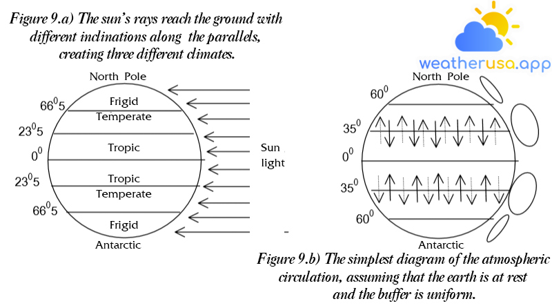
- As the earth rotates on its axis, a deflection force is produced, which affects the direction of displacement of the air currents; in addition, the quantity of the deflection force is proportional to the sine of the geographic latitude.
At about 30-35 degrees north or south latitude, the deflection force is large enough that the direction of movement of the upper air current, which is gradually deviating to the right, has wholly turned to the east.
These airflows are called anti-winds. Above latitudes more significant than 35°, the direction of air movement is west-east.
- In the equatorial belt, there is a solid upward flow of air from the ground to an altitude of over 4000 m. At latitudes 30-35°, the downward movement of air forms a belt of high pressure above the ground.
From this high-pressure belt, the gas flows move towards the equator in the direction NE – SW for the Northern Hemisphere and SW – NW for the Southern Hemisphere. These air currents are called nebulae.
Thus, wind and anti-wind form a closed vertical cycle. The high-pressure belt at 30-35° north or south is called the subtropical maximum.
- From the subtropical maximum (30-35° north or south), the air moves to the lower pressure area (60-65° north or south) in the direction SW – NE, northern hemisphere, and NW – SE, southern hemisphere, (see figure 48 b).
The cause of the minimum barometric belt at mid-latitudes 60-65° north and south is explained by cyclonic solid activity on it.
- At high latitudes, greater than 65° north and south, air currents will shift from the bipolar barometric maximum, where the year-round temperature is slow, to the barometric minimum at the mid-latitudes direction NE – SW, for the northern hemisphere and SE – NW, for the southern hemisphere.
Air currents close to the ground.
Realistic atmospheric circulation
- The actual atmospheric circulation is much more complicated. Because the land surface is divided into continents and oceans, faults of high-pressure zones are formed; due to the strong warming of summer on the continents, low pressure prevails. In the high-pressure seas, it divides itself into a series of closed anticyclones, and only in circulating oceans does the tropical wind manifest clearly, with the year-round wind direction being NE and E in the northern hemisphere but in the southern hemisphere, in the sea – SE and E.
- At middle and high latitudes, atmospheric circulation is much more complicated. The wind direction on the diagram is simply the most common in those regions, where many different and alternating cyclonic and anticyclonic circulations form. There are the following prevailing winds over the oceans:
Also, in the western Atlantic Ocean, near the east coast of North America and Canada – the prevailing northwesterly winds. These wind directions are closely related to Assorian anticyclones and inversions.
Therefore, the easterly direction of each of these anticyclones will be in the opposite direction.

Weather 01852 - Lowell MA

49°
overcast clouds
Feels like 46°05:56/19:31
51°F
/47°F
60%
1016 hPa
7 mi
8.05 mph


