Ice Breakup in Three Alaskan Rivers

Ice Breakup
Ice breakup is when ice cover, found on rivers, lakes, and seas, breaks up and melts in the spring or summer.
This process is a natural occurrence that occurs yearly as the weather warms and the sun shines for extended periods. Ice breakup is an important event for many ecosystems, as it can affect the availability of food and habitat for animals.
It can also significantly impact human activities, such as transportation and agriculture. In some areas, ice breakup is also accompanied by flooding, as the melting ice releases water that was previously trapped under the ice.
Communities Connecting: Ice Breakup in Three Alaskan Rivers
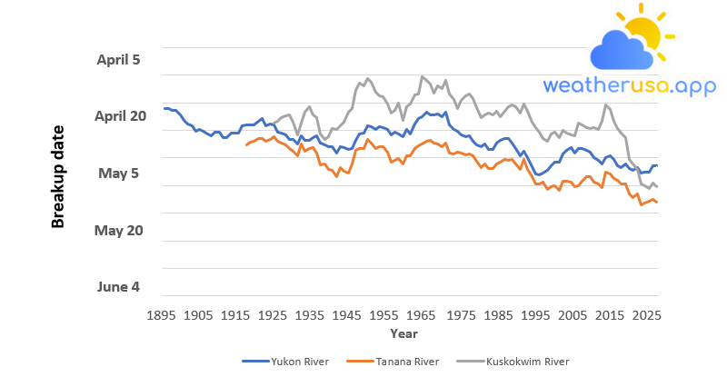
This figure shows annual ice melt dates at three locations: the town of Nenana on the Tanana River, Dawson City on the Yukon River, and Bethel on the Kuskokwim River. Annual data for each river have been plotted with a nine-year moving average.
| Year | Yukon River | Tanana River | Kuskokwim River |
| 1896 | 134 | ||
| 1897 | 134 | ||
| 1898 | 133.6667 | ||
| 1899 | 133.5556 | ||
| 1900 | 132.8889 | ||
| 1901 | 131.7778 | ||
| 1902 | 131.1111 | ||
| 1903 | 130.7778 | ||
| 1904 | 129.7778 | ||
| 1905 | 130.1111 | ||
| 1906 | 129.7778 | ||
| 1907 | 129.3333 | ||
| 1908 | 129 | ||
| 1909 | 129.6667 | ||
| 1910 | 129.6667 | ||
| 1911 | 128.7778 | ||
| 1912 | 128.6667 | ||
| 1913 | 129.4444 | ||
| 1914 | 129.4444 | ||
| 1915 | 129.4444 | ||
| 1916 | 130.7778 | ||
| 1917 | 131 | 127.4 | |
| 1918 | 131 | 127.9111 | |
| 1919 | 131 | 128.0889 | |
| 1920 | 131.6667 | 128.6 | |
| 1921 | 132.2222 | 128.5556 | |
| 1922 | 130.8889 | 128.1111 | |
| 1923 | 131.1111 | 128.3333 | |
| 1924 | 131 | 128.7778 | 131.4 |
| 1925 | 129.6667 | 128 | 131.6889 |
| 1926 | 129.4444 | 127.6667 | 132.3111 |
| 1927 | 129.1111 | 127.4444 | 132.7111 |
| 1928 | 128.3333 | 126.6667 | 132.8889 |
| 1929 | 128.3333 | 126.2222 | 131.5 |
| 1930 | 127.5556 | 125.4444 | 129.125 |
| 1931 | 129 | 127.5556 | 131.375 |
| 1932 | 128.2222 | 126.2222 | 133.25 |
| 1933 | 128.2222 | 126.7778 | 134.25 |
| 1934 | 128.7778 | 126.8889 | 132.875 |
| 1935 | 129 | 125.8889 | 132.2857 |
| 1936 | 127.6667 | 123.7778 | 129.4286 |
| 1937 | 127.3333 | 123.8889 | 128.4286 |
| 1938 | 127 | 123 | 128.875 |
| 1939 | 127 | 122.7778 | 130.375 |
| 1940 | 125.8889 | 121.6667 | 130.25 |
| 1941 | 127 | 123.3333 | 130.875 |
| 1942 | 126.8889 | 122.5556 | 131.5 |
| 1943 | 126.5556 | 122.2222 | 133.25 |
| 1944 | 126.6667 | 123.8889 | 133.8889 |
| 1945 | 128.2222 | 126.4444 | 137.2222 |
| 1946 | 129.3333 | 126.7778 | 138.5556 |
| 1947 | 129.5556 | 126.7778 | 138 |
| 1948 | 130.7778 | 128.4444 | 139.4444 |
| 1949 | 130.6667 | 127.7778 | 138.6667 |
| 1950 | 130.2222 | 126.6667 | 137 |
| 1951 | 130.6667 | 127.1111 | 136.3333 |
| 1952 | 130.5556 | 127 | 136.1111 |
| 1953 | 130.1111 | 126 | 134.7778 |
| 1954 | 129.1111 | 124.3333 | 133.2222 |
| 1955 | 129.6667 | 124.5556 | 133.5556 |
| 1956 | 129.3333 | 124.8889 | 134.8889 |
| 1957 | 128.8889 | 124 | 131.7778 |
| 1958 | 130.1111 | 125.4444 | 134.2222 |
| 1959 | 129.3333 | 125.3333 | 134.7778 |
| 1960 | 131.1111 | 126.6667 | 136.4444 |
| 1961 | 132.2222 | 127.2222 | 136.625 |
| 1962 | 132.4444 | 127.5556 | 139.75 |
| 1963 | 133.3333 | 128.1111 | 139.125 |
| 1964 | 132.7778 | 128.2222 | 138.375 |
| 1965 | 132.7778 | 127.6667 | 136.75 |
| 1966 | 133 | 127.5556 | 138.125 |
| 1967 | 132.5556 | 127.1111 | 137.625 |
| 1968 | 133.3333 | 127.7778 | 139.125 |
| 1969 | 131 | 125.8889 | 136.625 |
| 1970 | 130.1111 | 125.7778 | 135.5556 |
| 1971 | 129.8889 | 126 | 134 |
| 1972 | 129.2222 | 125.8889 | 135.4444 |
| 1973 | 128.8889 | 125.5556 | 136.3333 |
| 1974 | 129 | 125.7778 | 136.6667 |
| 1975 | 128 | 125.3333 | 135.7778 |
| 1976 | 127.4444 | 124.4444 | 134.1111 |
| 1977 | 127 | 123.2222 | 132.3333 |
| 1978 | 127.5556 | 123.8889 | 132.7778 |
| 1979 | 126.5556 | 123.1111 | 133.2222 |
| 1980 | 126.5556 | 123.1111 | 132.7778 |
| 1981 | 127.6667 | 124 | 133.4444 |
| 1982 | 128.2222 | 124.2222 | 132.4444 |
| 1983 | 128.5556 | 124.7778 | 133.4444 |
| 1984 | 128.5556 | 124.5556 | 134.3333 |
| 1985 | 127.6667 | 124.6667 | 134.5556 |
| 1986 | 126.7778 | 124 | 134.3333 |
| 1987 | 125.3333 | 123 | 133.2222 |
| 1988 | 126.2222 | 124.7778 | 134.7778 |
| 1989 | 125.1111 | 122.8889 | 133.4444 |
| 1990 | 123.4444 | 121.5556 | 131.4444 |
| 1991 | 122.1111 | 120.2222 | 130.5556 |
| 1992 | 122 | 120.3333 | 129.6667 |
| 1993 | 122.2222 | 120.5556 | 128.5556 |
| 1994 | 122.7778 | 119.3333 | 128 |
| 1995 | 123.6667 | 119.8889 | 129.3333 |
| 1996 | 124.3333 | 120 | 129.6667 |
| 1997 | 124.2222 | 119.2222 | 128.6667 |
| 1998 | 125.6667 | 120.7778 | 130 |
| 1999 | 126.3333 | 120.7778 | 129.4444 |
| 2000 | 126.8889 | 120.6667 | 129.1111 |
| 2001 | 125.8889 | 119.7778 | 129 |
| 2002 | 126.6667 | 120 | 131.3333 |
| 2003 | 126.6667 | 120.7778 | 131 |
| 2004 | 126.3333 | 121.6667 | 130.5556 |
| 2005 | 126 | 121.5556 | 130.3333 |
| 2006 | 125.1111 | 120.5556 | 130.4444 |
| 2007 | 124.5556 | 120.2222 | 130.1111 |
| 2008 | 124 | 119.6667 | 131.6667 |
| 2009 | 125.1111 | 122.4444 | 134.5556 |
| 2010 | 125.4444 | 122.1111 | 133.7778 |
| 2011 | 124.6667 | 121.2222 | 131.6667 |
| 2012 | 123.5556 | 120.8889 | 130.3333 |
| 2013 | 123.3333 | 120.2222 | 129.4444 |
| 2014 | 123.8889 | 120.2222 | 128.6667 |
| 2015 | 123.1111 | 118.5556 | 124.7778 |
| 2016 | 122.7778 | 117.8889 | 124 |
| 2017 | 123.2222 | 118.5556 | 122.8889 |
| 2018 | 122.3333 | 116.5556 | 120.2222 |
| 2019 | 122.5111 | 116.7778 | 119.9778 |
| 2020 | 122.4667 | 117.1111 | 119.5111 |
| 2021 | 123.5333 | 117.4444 | 120.4889 |
| 2022 | 123.6 | 117 | 119.8 |
Figure 1. Ice Breakup Dates for Three Alaskan Rivers, 1896-2022
Data source: Nenana Ice Classic, 2022; Yukon River Breakup, 2022; Kuskokwim Ice Classic, 2022; National Weather Service, 2022.
Web update: July 2022
Units: Days from January 1
Key Points
- The Tanana, Yukon, and Kuskokwim rivers show a long-term trend of melting ice earlier in the spring. The ice break dates for all three rivers shifted eight to nine days earlier than their respective record periods.
- The earliest recorded breakup date occurred within the past four years at all three locations.
- Although the general trend is to disintegrate earlier, the most recent river split dates are within historical variability.
Background
- Areas in the extreme north, such as Alaska, are warming faster than other parts of the world, and this trend is expected to continue. The Tanana, Yukon, and Kuskokwim rivers in Alaska provide an especially remarkable record of a northern climate.
For more than a century, locals have recorded the day the ice in these rivers begins to move or melt each spring. Some towns hold annual competitions to guess when the ice will melt.
- Since 1917, the Nenana Ice Classic on the Tanana River in central Alaska has paid out several million dollars in winnings to those who came closest to correctly guessing the date and time the glaciers will melt.
Similar traditions exist in Dawson City on the Yukon River, just across the Canadian border, where the date of parting is recorded since 1896, as well as in the Kuskokwim River in Bethel, where the date of departure is documented since 1924.
- However, breaking the ice on the river was more than just a friendly competition. The thaw is a critical transition time for the communities that rely on these relatively remote and free-flowing wild rivers for transportation, hunting, and fishing for subsistence and other needs other demand.
In addition, early thaw can lead to severe ice migration, congestion, infrastructure damage, and devastating flooding.
- The data collected by these communities clearly shows how the dates of river thaws in Nenana, Dawson City, and Bethel have changed over time. The towns all use the same method to measure the date and time when the ice melts in the river.
Residents place tripods on the ice in the middle of the river. This tripod is attached by cable to the meter on the shore.
When the ice under the tripod breaks or starts to move, the tripod moves, pulling the thread, and the clock stops.
About the Data
Notes
However, corresponding measurements of water conditions and air temperature help understand the link between changes in river thaw and climate changes.
A recent comparison with satellite measurements of ground freeze/thaw conditions shows a strong correlation between regional temperature conditions and the actual Tanana River rupture date.
Data Sources

Weather 01852 - Lowell MA

31°
clear sky
Feels like 25°05:47/19:38
34°F
/28°F
58%
1024 hPa
7 mi
5.75 mph


