Fluctuations in water levels World ocean Phenomenon of tides
Ocean and sea level
Sea level terms
Sea and ocean surface oscillation
- Many causes make sea and ocean levels unstable and unstable in continuous motion. The main force that drastically changes the water level is the moon’s and sun’s cosmic gravity, which causes the water level to fluctuate periodically.
- Influence of hydrometeorological processes, causing vertical and horizontal disturbances of water masses. We can cite: the change in pressure, causing the difference in the height of the sea.
When the barometric pressure increases by one mb, the sea level decreases by 10 mm, and conversely, when the pressure drops by 1 mb, the story of the sea increases by 10 mm. Evaporation, precipitation, and river flows are associated with water changes in different parts of the oceans and seas.
Variations in water density are responsible for fluctuations in sea and ocean levels. In addition, significant fluctuations in water levels can be caused by underground earthquakes. This phenomenon does not occur often or everywhere in the oceans and seas. - In nature, the fluctuations in the level of pure water mentioned above are not observed but only receive a combined effect caused by different causes.
The characteristics of water level fluctuations, often the most recognizable, are periodic. The cycle duration can be a day and a night, a month, a season, a year, or several years. - A type of period oscillation caused by random changes in wind direction and speed, precipitation, evaporation, etc.
Instruments for monitoring sea level fluctuations.
- The most straightforward and widely used tool is the water locator. Water is a metal ruler marked with horizontal lines divided by white and black squares. The width of a separator is usually 2 cm; there are also separators 1 dm wide.
Thuy Chi is firmly buried in the vertical direction, in a stable place, and the altitude does not change for long. The “0” point of the water solstice should be set so that the lowest water level has not yet reached it.
The waterway’s “0” landmark only forms the “0” story of the monitoring station and is usually linked to the national elevation system. The reading of the sea level by hydrology requires an accuracy of 1 cm; when its divisions are 2 cm, the accuracy is reduced to half a division.
When reading, observers should look directly at the solstice from the water, reading the dividing line near the edge of the water. When there is a wave, the fluctuating water level should read both high and low water levels, then take the average value. - For the continuous recording of water level fluctuations, tidal dynamics are used. There are two types of tide records: one located at the shore station; the other – off.
- The principle of operation of the first type is based on the modulation of the vertical displacement of a floating object, proportional to the removal of the needle, drawn on the strip of paper wound around the drum, driven in rotation by the clock structure.
- The second type is based on hydrodynamic pressure changes. The hydrodynamic pressure receiver is located on the seabed, away from the shore, or in the water near the beach.
Tidal phenomena
Important tidal definitions and terms.
Then, again, the sea level drops, and near the time the moon rises, the position of the sea level reaches its lowest point. After that, the sea level gradually rose again, depending on the moon’s height, as the sea level rose after the previous moonrise.
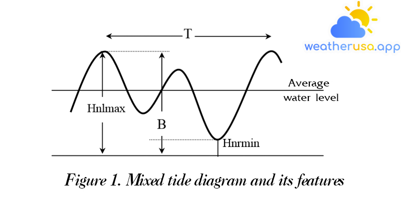
Thereby, the tides are repeats of the highest and lowest sea level after about the same time interval, about 12.5 hours. Waves of this type, known as semi-diurnal tides, are most commonly observed in the World Ocean.
If it is the Japanese cycle, the mixed tide is said to be irregular semi-diurnal; that is to say that the timing of the rising and falling tides is not the same, and when the diurnal-diurnal wave is periodic.
The influence of various factors on the quantities and characteristics of the tide.
Meanwhile, different amounts are observed on the continent’s coasts, especially in straits and long straits, where the amplitude can reach 12 m. Maximum tidal range observed in the Fandi Strait on the North American coast.
The enormous amplitude is due to Fandi’s waist being too long and narrow, accompanied by a gradual decrease in width and depth.
Stormy and robust winds can change the timing of high and low water, and the extreme wind is stable in one direction.
Explain the phenomenon of tides
- Tides, as mentioned above, occur due to the cosmic gravity of the moon and the sun. These forces are called tidal forces.
For the sake of simplicity, we first assume that the moon exerts only a tidal force on the components of the earth. - Like all other planets, the moon’s gravitational pull attracts particles of terrestrial matter, and the greater the distance to the moon’s center, the less force decreases.
More precisely, the strength of gravity is proportional to the product of the moon’s mass and the water element in question and inversely proportional to the square of the distance from the moon’s center to this element.
Thus, the amount of gravity is not equal for particles at different distances. Also, the directions of gravity are not parallel but are directed toward the center of the moon from different positions of the elements.

- In addition to the moon’s gravitational force, there is a centrifugal force, which acts on every element of matter. The centrifugal force is created by rotating the system of two earth-moon stars around their common center of gravity.
Calculations show that the general center of gravity is in the earth, at a distance of 0.73 times the planet’s radius. The moon makes one revolution around available gravity, with a period of precisely one lunar month. - It has been shown that the centrifugal force acts on every element of the earth of equal magnitude and in the direction of the meridian plane of the observer towards the moon.
- Each water element is solicited by two forces at the same time: the gravitational force of the moon and the centrifugal force. The vector sum of these two forces at each point is called the tidal force.
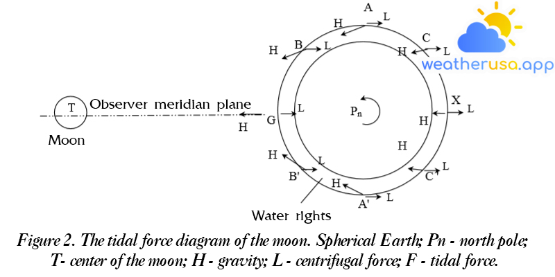
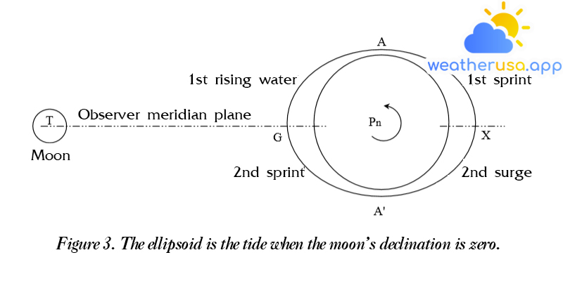
Suppose the world ocean covers the earth with a layer of water of equal thickness. The moon’s position on the diagram is not only in the plane of the observer’s meridian but also in the equatorial plane; that is, its declination is equal to 0°. - From figure 2, we see: in the water near points A and A’, the tidal force is directed vertically toward the center of the earth, lowering the water level; at points G and X – in the direction of the meridian plane, from the center of the world outwards, pulling water on either side of the meridian, causing the water level to rise, that is- that is to say towards great waters; at points, B, B’ and C, C’ are mutually symmetrical by the line – direction tangent to the sphere of water.
- Under tidal forces, the entire surface of the world ocean presents a tidal ellipse. Each half of the ellipse resembles a tidal wave with a peak at high water points and a base at low water points.
Due to the earth’s daily rotation, tidal waves constantly cross the bridge from west to east, and high and low levels cross each meridian.
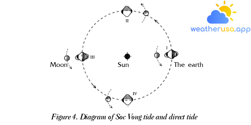
- In addition to the moon, the sun exerts tidal forces on the earth. Diagram of the tidal force formation due to the sun, similar to the moon.
However, since the sun is 390 times farther from the planet than the moon, even though its mass is 30 million times that of the moon, the sun’s tidal force is still less than its tidal force of 2, 17 times. - The two tidal force systems are entirely independent of each other, but by nature, they are connective, and composite moon-solar tides are observed. Due to the reciprocal positions of the earth, the moon and the sun constantly change, and their tidal forces also change.
They can combine to make the tide stronger, but in other places, they cancel each other out and weaken the wave. This affects the characteristics and quantities of the observed tides and clearly shows their changes.
Tidal difference
The daily tide difference
- The daily tide difference is caused by the difference in the height of high water and low water of mixed tides and the time of high tide and low water during the day.
The daily tidal difference depends on astronomical causes – lunar declination and solar declination and geographical conditions of the location. - These disparities are strongest in mixed tides. Indeed, during irregular diurnal tides, when the lunar declination is essential, the daily height difference at high water causes the loss of low tides and net high water, i.e., transition from a semi-diurnal wave to a purely diurnal tide.
- The difference depends on the lunar declination characteristic of the daily tides here; the tides reach a very high amplitude when the lunar declination is maximum.
These tides are called tropical tides. When the moon’s declination is zero, the tidal range is minimum, and it is called the equilibrium tide or the religion of the equinox. - The difference depends on the characteristic lunar phase of the semidiurnal tide. They include: the maximum amplitude of the tides observed on the days of the new and full moon, the periods of the moon, the sun, and the earth distributed on the same isoline, called squirrel tide, and The minimum when the moon and sun are distributed at right angles to the earth is called the orthogonal tide.
The semi-monthly tidal difference is usually dependent on altitude and time.
A monthly tidal difference
The long-term tidal difference
Tidal amplitude and characteristics on oceans and seas.
The largest tidal amplitude is observed in the Atlantic Ocean.
- At its peak, the amplitude can reach 18m, as in the Fandi Strait, which stretches between the North American continent and the New Sotlan peninsula.
This is the largest tidal amplitude for the entire World Ocean. In the port of Halegos on Argentina’s south coast, the measured tide is 14 m. - Near the southwest coast of England, significantly large tidal ranges are observed, up to 11.5 m in the Briston Strait, 8 m in Livecpun, and up to 6.3 m near the mouth of the More River. The island’s coastal area in the tidal range of Raikavik is 4 m.
- The tidal range of the islands off the ocean is about 1-2 m; for example, Adop islands are 1.2 – 1.8 m, and Tristan-da-Cunha island – is 1.5 m.
- The tides in the Atlantic Ocean are primarily semi-diurnal. The tidal features are particularly pronounced in the region near the west coast of Europe: the most unique.
In the Caribbean Sea and the strait of Mexico, tidal features are very diverse, including semi-diurnal, pure diurnal, and mixed tides.
Pacific
In the Indian Ocean, the most excellent tidal range
Tidal amplitude in the Arctic Ocean
BASICS OF PREVENTION OF INCOME FACTORS.
Calculating the factors of tides is essential for the safety of navigation and seaports.
The natural tidal phenomena are widely used in harmonic analysis.
The essence of harmonic analysis is that it is possible to view the complex curve of sea level change under the influence of tides as the summation form of standard component curves, each of which has the characteristics of simple harmonic oscillation Z as a sine wave:
Z = R cos (qt – ξ )
These component tidal waves, which can be seen more conveniently and simply as a result of the motion of some celestial bodies, rotate around the earth in circular orbits of different radii and at different rotational angular velocities.
Likewise, when the object’s mass, orbital radius, and angular momentum are included, a composite result can be obtained using the true tidal wave.
Therefore, the height of the water level at any time is determined by the formula:
H – average tidal amplitude depending on geographical conditions.
g is the wave position angle that determines the slow arrival of the high water moment of each component wave relative to a particular tidal wave, or, in other words, the moment that crosses the celestial meridian causing the characteristic deviation.
According to the stationary tide phase, natural wave characteristics depend on local conditions.
- The tidal amplitude H and the angle of the g-wave location are determined by the data observed for that location. They are invariant quantities, and hence they are called harmonic constants.
- The harmonic analysis problem includes 1/ determining the harmonic constants, 2/ estimating the standard tidal height at a particular point in time, and 3/taking into account the main tidal factors of a given topic.
- The complete formula with tide height calculation includes 93 components. However, in practice, it is necessary to determine only 8 main features of waves for deep sea and 11 for shallow water.
- Based on the harmonic analysis, a tide table is created. It is possible to pre-calculate the tide factors in different ports – high water heights, low tides, when they are reached, and other characteristics of the waves at any time.
- Tide tables or tide calendars are the official way of calculating tide elements on ships. They are published annually.
- In developed countries, the tidal calendar consists of several sets that pre-calculate tidal factors for almost all major ports in the seas of the World Ocean.
Most of these calendars usually have two main parts: Part I – high-water and low-water advance tables for large ports; part II – main indication for tide calculations for small ports; and some other auxiliary tables.
– Determine the time when the tide reaches the given maximum value

Weather 01852 - Lowell MA

58°
clear sky
Feels like 56°06:01/19:28
61°F
/55°F
50%
1017 hPa
7 mi
8.05 mph


